
Sumang LRT Station
Sumang LRT station, coded PW6, sits on the Punggol LRT West Loop and forms part of the light rail network serving Punggol new town in the north-east of Singapore. It is not an interchange station. The station is surrounded by a predominantly residential area, serving the housing estates and amenities that make up this planned public housing town developed by the Housing and Development Board.
Sumang on the Punggol LRT (West Loop) map
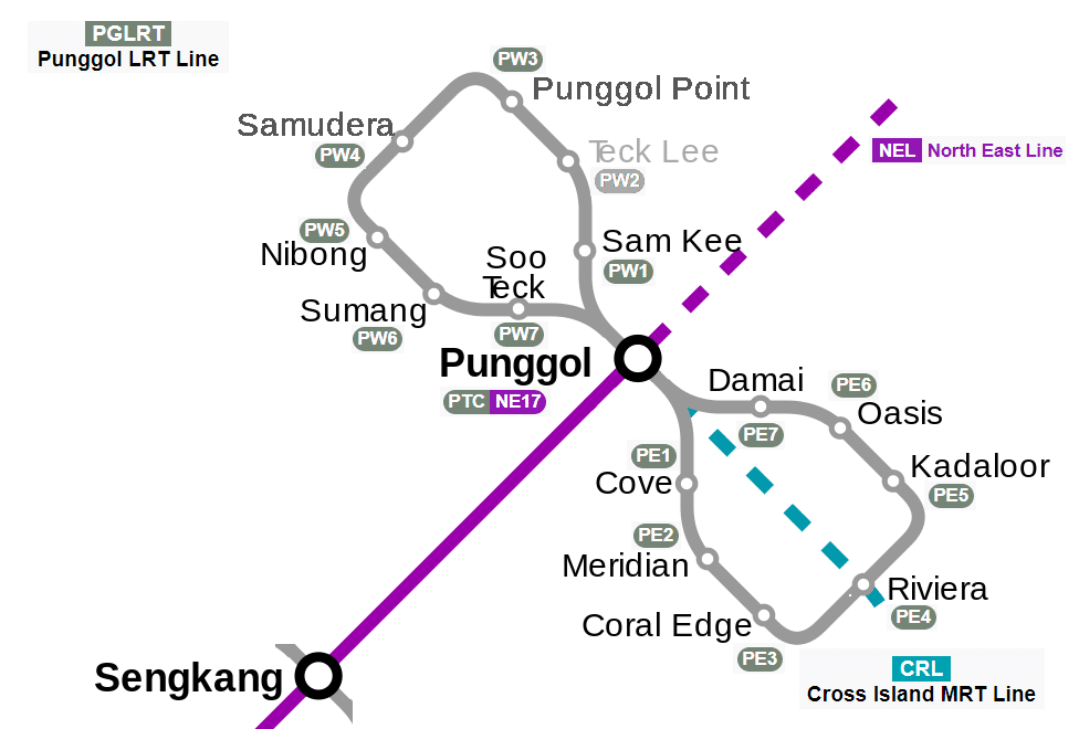
Sumang LRT station at a glance
| Station codes | PW6 |
|---|---|
| Lines | Punggol LRT (West Loop) |
| Line colour | Grey line (Punggol LRT (West Loop)) |
| Interchange | No, single line station |
| Chinese name | 苏芒 |
| Tamil name | சுமாங் |
| Next stations |
See Sumang on the map. The interactive map opens with this station highlighted, so you can trace the route from where you are.
Travelling from Sumang, you can reach Nibong station in one direction and Soo Teck station in the other, both on the same Punggol LRT West Loop. To connect to the MRT network, you would need to continue along the loop to Punggol station, which is the terminus of the Punggol LRT and also serves the North East Line, giving access to the broader Singapore rail network from there.
The immediate surroundings of Sumang station are typical of a Punggol residential precinct, with HDB blocks, neighbourhood shops, and local amenities within walking distance. The area is part of a relatively young and still developing town, so the neighbourhood has a modern, low-rise residential character. Residents mainly use the station for daily commutes to Punggol MRT station, rather than as a destination in its own right for visitors.
Around Sumang LRT station
Sumang LRT station sits within a modern residential precinct in Punggol, surrounded by public housing estates and waterway greenery. The station is steps away from Foodgle food centre and the leisure greenery of My Waterway@Punggol park. Waterway Point shopping mall is also reachable on foot, making the area well served for everyday needs.
| Place | Type | Distance | Why go |
|---|---|---|---|
| Foodgle | Food centre | About 60 m (~1 min walk) | Visit Foodgle for a convenient selection of hawker stalls and cooked food options. |
| My Waterway@Punggol | Park | About 120 m (~2 min walk) | Head to My Waterway@Punggol for a stroll along the park and waterway greenery. |
| 7 Lucky Star Coffee Shop | Food centre | About 320 m (~5 min walk) | 7 Lucky Star Coffee Shop is a neighbourhood coffeeshop suitable for casual meals. |
| Kimly Coffeeshop | Food centre | About 370 m (~6 min walk) | Kimly Coffeeshop is a local coffeeshop good for everyday eating and drinks. |
| Punggol Parc Terraces Residents' Network | Community club | About 380 m (~6 min walk) | Punggol Parc Terraces Residents' Network serves as a community hub for local residents. |
| Punggol BayVue Residents' Network | Community club | About 420 m (~7 min walk) | Punggol BayVue Residents' Network is a community facility for neighbourhood programmes and events. |
| Waterway Point | Shopping mall | About 460 m (~7 min walk) | Waterway Point offers a range of retail, dining and entertainment options. |
| Northshore Plaza I | Shopping mall | About 990 m (~16 min walk) | Northshore Plaza I provides additional shopping and dining further from the station. |
Places and straight-line distances from OpenStreetMap data (© OpenStreetMap contributors). Actual walking routes may be longer.
How to get to Sumang by LRT
Worked out from the network map. Stop counts are station to station and do not include walking or waiting time.
| From Changi Airport | Take the East West Line from Changi Airport to Paya Lebar (6 stops), then change to the Circle Line from Paya Lebar to Serangoon (4 stops), then change to the North East Line from Serangoon to Punggol (5 stops), then change to the Punggol LRT from Punggol to Sumang (2 stops). About 17 stops with 3 changes. |
|---|---|
| From Orchard | Take the North South Line from Orchard to Dhoby Ghaut (2 stops), then change to the North East Line from Dhoby Ghaut to Punggol (11 stops), then change to the Punggol LRT from Punggol to Sumang (2 stops). About 15 stops with 2 changes. |
| From City Hall | Take the North South Line from City Hall to Dhoby Ghaut (1 stop), then change to the North East Line from Dhoby Ghaut to Punggol (11 stops), then change to the Punggol LRT from Punggol to Sumang (2 stops). About 14 stops with 2 changes. |
| From Jurong East | Take the East West Line from Jurong East to Buona Vista (3 stops), then change to the Circle Line from Buona Vista to Serangoon (8 stops), then change to the North East Line from Serangoon to Punggol (5 stops), then change to the Punggol LRT from Punggol to Sumang (2 stops). About 18 stops with 3 changes. |
| From Woodlands | Take the North South Line from Woodlands to Bishan (8 stops), then change to the Circle Line from Bishan to Serangoon (2 stops), then change to the North East Line from Serangoon to Punggol (5 stops), then change to the Punggol LRT from Punggol to Sumang (2 stops). About 17 stops with 3 changes. |
| From HarbourFront | Take the North East Line from HarbourFront to Punggol (15 stops), then change to the Punggol LRT from Punggol to Sumang (2 stops). About 17 stops with 1 change. |
Fares from Sumang LRT station
A trip from Sumang to Changi Airport (about 27 km) costs S$2.43 on an adult SimplyGo or EZ-Link card. Fares are charged by distance, so the table below shows the estimated adult card fare from Sumang to the main hubs, the early bird fare for journeys that start before 7.45am on weekdays, and the fare that applies from 26 December 2026.
| To | Distance | Adult card | Before 7.45am | From 26 Dec 2026 |
|---|---|---|---|---|
| Changi Airport | about 27 km, 17 stops | S$2.43 | S$1.93 | S$2.56 |
| Orchard | about 18 km, 15 stops | S$2.20 | S$1.70 | S$2.33 |
| City Hall | about 17 km, 14 stops | S$2.20 | S$1.70 | S$2.33 |
| Raffles Place | about 19 km, 15 stops | S$2.24 | S$1.74 | S$2.37 |
| Jurong East | about 28 km, 18 stops | S$2.45 | S$1.95 | S$2.58 |
| Woodlands | about 29 km, 17 stops | S$2.46 | S$1.96 | S$2.59 |
| HarbourFront | about 22 km, 17 stops | S$2.33 | S$1.83 | S$2.46 |
| Marina Bay | about 21 km, 19 stops | S$2.30 | S$1.80 | S$2.43 |
Estimated from the route distance between stations and the Public Transport Council fare table in force from 27 December 2025. The exact fare can differ by one band. Cash fares are higher. Use the fare calculator for any other journey, or check your fare on the SimplyGo app.
Tips for using Sumang LRT station
- Foodgle and My Waterway@Punggol are both within a very short walk, so no extra planning is needed to visit them after alighting.
- Waterway Point is approximately 7 minutes on foot at a comfortable pace, though allow a little extra time during busy periods.
- Northshore Plaza I is roughly 16 minutes away on foot, so consider taking the LRT to a closer station or using surface transport to save time.
- During peak commuting hours the Punggol LRT can be busy, so factor in a few extra minutes when connecting to or from Punggol MRT station.
All stations on the Punggol LRT (West Loop)
In order along the line, with Sumang marked. Stations with their own guide are linked.
| Code | Station | Interchange |
|---|---|---|
| PW1 | Sam Kee | None |
| PW2 | Teck Lee | None |
| PW3 | Punggol Point | None |
| PW4 | Samudera | None |
| PW5 | Nibong | None |
| PW6 | Sumang (you are here) | None |
| PW7 | Soo Teck | None |
Read the full Punggol LRT (West Loop) guide.
Sumang LRT station: common questions
Which line is Sumang LRT station on?
Sumang is on the Punggol LRT (West Loop). Its station code is PW6.
Is Sumang an interchange station?
No. Sumang is served by the Punggol LRT (West Loop) only. The nearest interchange is shown in the next stations row above.
What is near Sumang LRT station?
Nearby places include Foodgle food centre at about 60 m, My Waterway@Punggol park at about 120 m, and Waterway Point shopping mall at about 460 m. There are also several neighbourhood coffeeshops and community facilities within roughly 6 to 7 minutes on foot.
Which food centre is closest to Sumang station?
Foodgle is the closest food centre, approximately 60 m from the station, making it roughly a 1-minute walk.
How far is Waterway Point from Sumang LRT station?
Waterway Point is approximately 460 m from Sumang station, which is roughly a 7-minute walk at an average pace.
How do I get to Sumang from Changi Airport by LRT?
Take the East West Line from Changi Airport to Paya Lebar (6 stops), then change to the Circle Line from Paya Lebar to Serangoon (4 stops), then change to the North East Line from Serangoon to Punggol (5 stops), then change to the Punggol LRT from Punggol to Sumang (2 stops). About 17 stops with 3 changes.
Sources: station codes, line colours and interchanges from the LTA rail system map; operating hours from SMRT and SBS Transit. Last reviewed September 2026.
Plan the rest of the trip
Every station on the Punggol LRT (West Loop) is listed on its line guide, with the full route and interchanges. For times, see the first and last train guide, and for the whole network in one view use the interactive Singapore MRT map or the PDF map.