
Punggol Point LRT Station
Punggol Point LRT station is a stop on the West Loop of the Punggol LRT, where it carries the station code PW3. It lies in the Punggol Coast area in the north of Punggol. Like every other stop on this 10.3 km driverless line, it is elevated, with trains running on a viaduct above street level.
Punggol Point on the Punggol LRT (West Loop) map
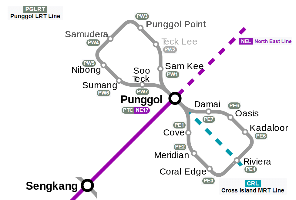
Punggol Point LRT station at a glance
| Station codes | PW3 |
|---|---|
| Lines | Punggol LRT (West Loop) |
| Line colour | Grey line (Punggol LRT (West Loop)) |
| Interchange | No, single line station |
| Chinese name | 榜鹅坊 |
| Tamil name | பொங்கோல் பாயிண்ட் |
| Next stations |
See Punggol Point on the map. The interactive map opens with this station highlighted, so you can trace the route from where you are.
The station mainly serves people living in the surrounding neighbourhood. It is also used by students and staff travelling to the Singapore Institute of Technology and by passengers transferring to buses at the nearby Punggol Coast Bus Interchange. Anyone heading further afield rides the West Loop to Punggol station, where the two LRT loops meet and connect with the North East Line of the MRT network.
History of Punggol Point LRT station
Punggol Point LRT station opened on 29 December 2016, about two and a half years after the West Loop began carrying passengers with just three stations in June 2014. That same day, two-car trains entered passenger service on the Punggol LRT for the first time, running on the East Loop. When the station first opened, West Loop trains ran in only one direction, which changed depending on the time of day. Services in both directions began on 29 September 2018 as more people used the loop.
Inside Punggol Point LRT station
Trains here are fully automated Crystal Mover vehicles built by Mitsubishi Heavy Industries, and they run without drivers. In 2025 a new fleet of 25 two-car trains entered service across the line, replacing the older single-car trains and some of the earlier two-car sets. This gives passengers more room on board at busy times.
For most riders, the station is a practical base for daily errands and meals within a short walk. The Punggol Coast Hawker Centre is about 320 m away, roughly a five-minute walk, and the Kimly Coffeeshop is a similar distance. Both are good choices for an inexpensive meal. Shoppers can reach Northshore Plaza I in around eight minutes on foot, and Northshore Plaza II is a little further on.
Families looking for a day out with children can walk to Splash @ Kidz Amaze, a water park about 750 m from Punggol Point LRT station. Students will find the Singapore Institute of Technology campus around twelve minutes away on foot. The Punggol Coast Bus Interchange, about four minutes’ walk away, makes it easy to continue a journey by bus to other parts of the north east.
Around Punggol Point LRT station
Punggol Point LRT station sits within a modern waterfront residential precinct in the north-east of Singapore. The area around the station is largely made up of newer public housing estates alongside facilities such as Punggol Coast Bus Interchange and Punggol Coast Hawker Centre. Northshore Plaza I and II add a retail dimension to what is primarily a growing residential neighbourhood.
| Place | Type | Distance | Why go |
|---|---|---|---|
| Punggol Coast Bus Interchange | Bus interchange | About 260 m (~4 min walk) | Catch local bus services connecting Punggol Point to other parts of Singapore. |
| Kimly Coffeeshop | Food centre | About 310 m (~5 min walk) | A neighbourhood coffeeshop offering local food and drinks for nearby residents. |
| Punggol Coast Hawker Centre | Food centre | About 320 m (~5 min walk) | A public hawker centre with a range of local food stalls to choose from. |
| Northshore Plaza I | Shopping mall | About 510 m (~8 min walk) | A neighbourhood shopping mall with retail shops and dining options. |
| Maxim Tam Chiak kopitiam | Food centre | About 530 m (~9 min walk) | A kopitiam serving local meals and beverages in a casual setting. |
| Northshore Plaza II | Shopping mall | About 600 m (~10 min walk) | A second shopping mall complementing the retail offerings in the Northshore area. |
| Singapore Institute of Technology | University | About 710 m (~12 min walk) | A university campus offering degree programmes in applied learning disciplines. |
| Splash @ Kidz Amaze | Water park | About 750 m (~12 min walk) | An indoor water play facility aimed at younger children and families. |
Places and straight-line distances from OpenStreetMap data (© OpenStreetMap contributors). Actual walking routes may be longer.
How to get to Punggol Point by LRT
Worked out from the network map. Stop counts are station to station and do not include walking or waiting time.
| From Changi Airport | Take the East West Line from Changi Airport to Paya Lebar (6 stops), then change to the Circle Line from Paya Lebar to Serangoon (4 stops), then change to the North East Line from Serangoon to Punggol (5 stops), then change to the Punggol LRT from Punggol to Punggol Point (3 stops). About 18 stops with 3 changes. |
|---|---|
| From Orchard | Take the North South Line from Orchard to Dhoby Ghaut (2 stops), then change to the North East Line from Dhoby Ghaut to Punggol (11 stops), then change to the Punggol LRT from Punggol to Punggol Point (3 stops). About 16 stops with 2 changes. |
| From City Hall | Take the North South Line from City Hall to Dhoby Ghaut (1 stop), then change to the North East Line from Dhoby Ghaut to Punggol (11 stops), then change to the Punggol LRT from Punggol to Punggol Point (3 stops). About 15 stops with 2 changes. |
| From Jurong East | Take the East West Line from Jurong East to Buona Vista (3 stops), then change to the Circle Line from Buona Vista to Serangoon (8 stops), then change to the North East Line from Serangoon to Punggol (5 stops), then change to the Punggol LRT from Punggol to Punggol Point (3 stops). About 19 stops with 3 changes. |
| From Woodlands | Take the North South Line from Woodlands to Bishan (8 stops), then change to the Circle Line from Bishan to Serangoon (2 stops), then change to the North East Line from Serangoon to Punggol (5 stops), then change to the Punggol LRT from Punggol to Punggol Point (3 stops). About 18 stops with 3 changes. |
| From HarbourFront | Take the North East Line from HarbourFront to Punggol (15 stops), then change to the Punggol LRT from Punggol to Punggol Point (3 stops). About 18 stops with 1 change. |
Fares from Punggol Point LRT station
A trip from Punggol Point to Changi Airport (about 27 km) costs S$2.44 on an adult SimplyGo or EZ-Link card. Fares are charged by distance, so the table below shows the estimated adult card fare from Punggol Point to the main hubs, the early bird fare for journeys that start before 7.45am on weekdays, and the fare that applies from 26 December 2026.
| To | Distance | Adult card | Before 7.45am | From 26 Dec 2026 |
|---|---|---|---|---|
| Changi Airport | about 27 km, 18 stops | S$2.44 | S$1.94 | S$2.57 |
| Orchard | about 18 km, 16 stops | S$2.24 | S$1.74 | S$2.37 |
| City Hall | about 18 km, 15 stops | S$2.20 | S$1.70 | S$2.33 |
| Raffles Place | about 19 km, 16 stops | S$2.24 | S$1.74 | S$2.37 |
| Jurong East | about 29 km, 19 stops | S$2.45 | S$1.95 | S$2.58 |
| Woodlands | about 30 km, 18 stops | S$2.46 | S$1.96 | S$2.59 |
| HarbourFront | about 22 km, 18 stops | S$2.36 | S$1.86 | S$2.49 |
| Marina Bay | about 21 km, 20 stops | S$2.33 | S$1.83 | S$2.46 |
Estimated from the route distance between stations and the Public Transport Council fare table in force from 27 December 2025. The exact fare can differ by one band. Cash fares are higher. Use the fare calculator for any other journey, or check your fare on the SimplyGo app.
Tips for using Punggol Point LRT station
- Punggol Coast Bus Interchange is only a short walk from the station and is useful for onward travel across the island.
- Northshore Plaza I and II are a moderate walk away, so factor in extra time if you are heading there on a warm day.
- Singapore Institute of Technology and Splash @ Kidz Amaze are the furthest verified destinations, each roughly a 12-minute walk, so allow extra time especially at peak hours.
- The Punggol LRT West Loop operates as a loop service, so check the direction of travel at the platform to ensure you board a train heading the right way around.
All stations on the Punggol LRT (West Loop)
In order along the line, with Punggol Point marked. Stations with their own guide are linked.
| Code | Station | Interchange |
|---|---|---|
| PW1 | Sam Kee | None |
| PW2 | Teck Lee | None |
| PW3 | Punggol Point (you are here) | None |
| PW4 | Samudera | None |
| PW5 | Nibong | None |
| PW6 | Sumang | None |
| PW7 | Soo Teck | None |
Read the full Punggol LRT (West Loop) guide.
Punggol Point LRT station: common questions
Which line is Punggol Point LRT station on?
Punggol Point is on the Punggol LRT (West Loop). Its station code is PW3.
Is Punggol Point an interchange station?
No. Punggol Point is served by the Punggol LRT (West Loop) only. The nearest interchange is shown in the next stations row above.
What is near Punggol Point LRT station?
Nearby places include Punggol Coast Bus Interchange at approximately 260 m, Punggol Coast Hawker Centre at approximately 320 m, Northshore Plaza I and II, Singapore Institute of Technology, and Splash @ Kidz Amaze, among others.
Which food centre or hawker centre is closest to Punggol Point station?
Kimly Coffeeshop is the closest food option at approximately 310 m, followed by Punggol Coast Hawker Centre at approximately 320 m, both roughly a 5-minute walk.
How far is Northshore Plaza from Punggol Point station?
Northshore Plaza I is approximately 510 m away, roughly an 8-minute walk, while Northshore Plaza II is approximately 600 m away, roughly a 10-minute walk.
How do I get to Punggol Point from Changi Airport by LRT?
Take the East West Line from Changi Airport to Paya Lebar (6 stops), then change to the Circle Line from Paya Lebar to Serangoon (4 stops), then change to the North East Line from Serangoon to Punggol (5 stops), then change to the Punggol LRT from Punggol to Punggol Point (3 stops). About 18 stops with 3 changes.
Sources: station codes, line colours and interchanges from the LTA rail system map; operating hours from SMRT and SBS Transit. Last reviewed October 2026.
News and guides mentioning Punggol Point
- シンガポールMRT路線図 2026(日本語ガイド) 4 Oct 2026
- Sengkang-Punggol LRT 11 Aug 2023
- Tamil 11 Aug 2023
- MRT Map Chinese 11 Aug 2023
Plan the rest of the trip
Every station on the Punggol LRT (West Loop) is listed on its line guide, with the full route and interchanges. For times, see the first and last train guide, and for the whole network in one view use the interactive Singapore MRT map or the PDF map.