
Pasir Panjang MRT Station
Pasir Panjang MRT station is a station on the Circle Line, carrying the station code CC26. It is not an interchange station. The station serves a quiet, primarily residential and light industrial stretch of the southern corridor, sitting between the waterfront and the forested ridge of Telok Blangah Hill. The area has a low-rise, unhurried character compared to the busier parts of the Circle Line closer to the city centre.
Pasir Panjang on the Circle Line map
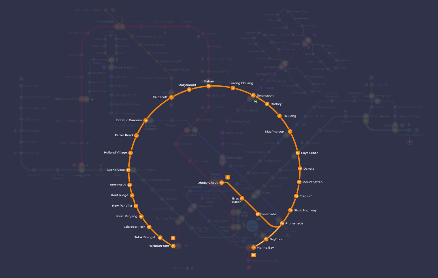
Pasir Panjang station at a glance
| Station codes | CC26 |
|---|---|
| Lines | Circle Line |
| Interchange | No, single line station |
| Chinese name | 巴西班让 |
| Tamil name | பாசிர் பாஞ்சாங் |
| Next stations | |
| Train times | Circle Line: first train leaves the terminus at 5:37 AM, last train 11:50 PM Full first and last train guide |
See Pasir Panjang on the map. The interactive map opens with this station highlighted, so you can trace the route from where you are.
From Pasir Panjang, you can travel directly along the Circle Line without changing trains. The neighbouring station to the east is Haw Par Villa (CC25), and to the west is Labrador Park (CC27). Because the Circle Line loops around the city, staying on it allows you to reach major interchanges such as HarbourFront, one-north, Buona Vista, and Holland Village without needing to transfer, making the station reasonably well connected despite its quieter setting.
The surrounding neighbourhood is a low-density residential area with some local shops and eateries along Pasir Panjang Road. The station is also within reasonable walking distance of Pasir Panjang Wholesale Centre, a large market dealing in fresh produce, which draws traders and shoppers from across the city. Beyond that, the area offers a generally calm, green environment with tree-lined streets, making it a pleasant part of the city to explore on foot.
Around Pasir Panjang station
Pasir Panjang station sits in a mixed neighbourhood of residential blocks, light industrial premises and green spaces along the southern edge of Singapore. The area is known for its proximity to nature, with Pasir Panjang Park and Kent Ridge Park both within walking distance. Everyday dining needs are well served, with Pasir Panjang Food Centre just moments from the station exit.
| Place | Type | Distance | Why go |
|---|---|---|---|
| Pasir Panjang Food Centre | Food centre | About 30 m (~1 min walk) | Visit for a wide variety of local hawker food and drinks. |
| Rice Bowl | Food centre | About 170 m (~3 min walk) | A neighbourhood food centre offering casual cooked food options. |
| Eng Lock Koo Coffeeshop | Food centre | About 230 m (~4 min walk) | A traditional coffeeshop serving local food and beverages. |
| Jambol Place Park | Park | About 340 m (~6 min walk) | A small neighbourhood park suitable for a quiet outdoor stroll. |
| Pasir Panjang Park | Park | About 400 m (~7 min walk) | A waterfront park along the southern coastline for leisure walks. |
| Reflections at Bukit Chandu | Museum | About 470 m (~8 min walk) | A museum commemorating the Battle of Pasir Panjang and wartime history. |
| Masjid Ahmad | Place of worship | About 690 m (~11 min walk) | A local mosque serving the Muslim community in the area. |
| Kent Ridge Park | Park | About 810 m (~13 min walk) | A larger hilltop park with forested trails and open green spaces. |
Places and straight-line distances from OpenStreetMap data (© OpenStreetMap contributors). Actual walking routes may be longer.
How to get to Pasir Panjang by MRT
Worked out from the network map. Stop counts are station to station and do not include walking or waiting time.
| From Changi Airport | Take the East West Line from Changi Airport to Paya Lebar (6 stops), then change to the Circle Line from Paya Lebar to Pasir Panjang (16 stops). About 22 stops with 1 change. |
|---|---|
| From Orchard | Take the North South Line from Orchard to Dhoby Ghaut (2 stops), then change to the North East Line from Dhoby Ghaut to HarbourFront (3 stops), then change to the Circle Line from HarbourFront to Pasir Panjang (3 stops). About 8 stops with 2 changes. |
| From City Hall | Take the North South Line from City Hall to Dhoby Ghaut (1 stop), then change to the North East Line from Dhoby Ghaut to HarbourFront (3 stops), then change to the Circle Line from HarbourFront to Pasir Panjang (3 stops). About 7 stops with 2 changes. |
| From Jurong East | Take the East West Line from Jurong East to Buona Vista (3 stops), then change to the Circle Line from Buona Vista to Pasir Panjang (4 stops). About 7 stops with 1 change. |
| From Woodlands | Take the Thomson East Coast Line from Woodlands to Caldecott (6 stops), then change to the Circle Line from Caldecott to Pasir Panjang (8 stops). About 14 stops with 1 change. |
| From HarbourFront | Take the Circle Line from HarbourFront to Pasir Panjang (3 stops). About 3 stops, no changes. |
Tips for using Pasir Panjang station
- Pasir Panjang Food Centre is the closest dining option, roughly a one-minute walk from the station, making it the most convenient choice for a quick meal.
- Kent Ridge Park and Reflections at Bukit Chandu are over 400 metres away, so allow at least 10 to 15 minutes on foot or consider taking a local bus to reduce walking time.
- For visits to Kent Ridge Park, plan for a longer outing as the terrain is hilly and the walk from the station is approximately 13 minutes at a comfortable pace.
- The Circle Line runs frequently, but during peak hours trains can be busy; plan your journey with a small buffer if you are heading to multiple destinations in the area.
All stations on the Circle Line
In order along the line, with Pasir Panjang marked. Stations with their own guide are linked.
| Code | Station | Interchange |
|---|---|---|
| CC2 | Bras Basah | – |
| CC3 | Esplanade | – |
| CC4 | Promenade | CC / DT |
| CC5 | Nicoll Highway | – |
| CC6 | Stadium | – |
| CC7 | Mountbatten | – |
| CC8 | Dakota | – |
| CC9 | Paya Lebar | CC / EW |
| CC10 | MacPherson | CC / DT |
| CC11 | Tai Seng | – |
| CC12 | Bartley | – |
| CC13 | Serangoon | CC / NE |
| CC14 | Lorong Chuan | – |
| CC15 | Bishan | NS / CC |
| CC16 | Marymount | – |
| CC17 | Caldecott | CC / TE |
| CC19 | Botanic Gardens | DT / CC |
| CC20 | Farrer Road | – |
| CC21 | Holland Village | – |
| CC22 | Buona Vista | EW / CC |
| CC23 | one-north | – |
| CC24 | Kent Ridge | – |
| CC25 | Haw Par Villa | – |
| CC26 | Pasir Panjang (you are here) | – |
| CC27 | Labrador Park | – |
| CC28 | Telok Blangah | – |
| CC29 | HarbourFront | CC / NE |
Read the full Circle Line guide.
Pasir Panjang station: common questions
Which line is Pasir Panjang MRT station on?
Pasir Panjang is on the Circle Line. Its station code is CC26.
Is Pasir Panjang an interchange station?
No. Pasir Panjang is served by the Circle Line only. The nearest interchange is shown in the next stations row above.
What time is the first and last train at Pasir Panjang?
Times below are for the first and last train leaving the line terminus; trains reach Pasir Panjang a few minutes later depending on its position on the line. Circle Line first train 5:37 AM, last train 11:50 PM. Check the operator for holiday changes.
What is near Pasir Panjang MRT station?
The station is close to several dining options including Pasir Panjang Food Centre at approximately 30 metres, as well as green spaces such as Pasir Panjang Park and Kent Ridge Park. Reflections at Bukit Chandu, a museum about wartime history, is also within walking distance at approximately 470 metres.
Which food centre is closest to Pasir Panjang station?
Pasir Panjang Food Centre is the closest, at approximately 30 metres from the station, making it roughly a one-minute walk.
How far is Kent Ridge Park from Pasir Panjang MRT station?
Kent Ridge Park is approximately 810 metres away in a straight line, which is roughly a 13-minute walk from the station.
How do I get to Pasir Panjang from Changi Airport by MRT?
Take the East West Line from Changi Airport to Paya Lebar (6 stops), then change to the Circle Line from Paya Lebar to Pasir Panjang (16 stops). About 22 stops with 1 change.
Sources: station codes, line colours and interchanges from the LTA rail system map; operating hours from SMRT and SBS Transit. Last reviewed September 2026.
News and guides mentioning Pasir Panjang
- Greater Southern Waterfront: MRT Access & Freehold Top Buyer Priorities 27 Jul 2026
- Tanjong Pagar Distripark & SAM: Singapore Arts Guide 24 Jul 2026
Plan the rest of the trip
Every station on the Circle Line is listed on its line guide, with the full route and interchanges. For times, see the first and last train guide, and for the whole network in one view use the interactive Singapore MRT map or the PDF map.