
Stadium MRT Station
Stadium MRT station is a station on the Circle Line, carrying the station code CC6. It sits in the Kallang area of central Singapore, serving a district best known for its sports and entertainment facilities. The surrounding area is a mix of open recreational space, large-scale event venues, and some residential development a short distance away, making it a station that sees particularly heavy use on event days.
Stadium on the Circle Line map
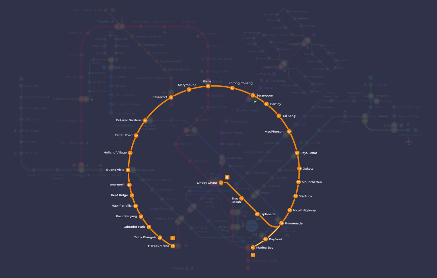
Stadium station at a glance
| Station codes | CC6 |
|---|---|
| Lines | Circle Line |
| Interchange | No, single line station |
| Chinese name | 体育场 |
| Tamil name | ஸ்டேடியம் |
| Next stations | |
| Train times | Circle Line: first train leaves the terminus at 5:37 AM, last train 11:50 PM Full first and last train guide |
See Stadium on the map. The interactive map opens with this station highlighted, so you can trace the route from where you are.
Stadium station does not serve as an interchange, so passengers needing to change lines will have to travel to a neighbouring station. On the Circle Line, the two adjacent stations are Nicoll Highway (CC5) and Mountbatten (CC7). From those stations, or by continuing further along the Circle Line, travellers can reach interchanges connecting to the North-South, East-West, Downtown, and other lines across the network.
The most prominent landmark within walking distance is the Singapore Sports Hub, a large complex that includes the National Stadium, the Singapore Indoor Stadium, and an aquatic centre. The area around the station is largely given over to this complex and its surrounding open spaces, so it is the main destination most visitors are heading to when they alight here. The nearby Kallang riverside also offers walking routes along the water.
Around Stadium station
Stadium MRT station sits within the Kallang sports and leisure precinct, a district dominated by large-scale sporting and entertainment venues. The area is anchored by the National Stadium and Singapore Indoor Stadium, drawing visitors for concerts, matches and recreational activities. Shopping and dining options such as Kallang Wave Mall and Leisure Park Kallang serve the many visitors who pass through.
| Place | Type | Distance | Why go |
|---|---|---|---|
| Yum Yum | Food centre | About 100 m (~2 min walk) | Visit for local hawker food and casual dining options. |
| Leisure Park Kallang | Shopping mall | About 140 m (~2 min walk) | Visit for shopping, dining and entertainment under one roof. |
| National Stadium | Stadium | About 220 m (~4 min walk) | Visit for major sporting events, concerts and large-scale performances. |
| My Kampung | Food centre | About 230 m (~4 min walk) | Visit for local hawker food in a community-oriented setting. |
| Kallang Wave Mall | Shopping mall | About 250 m (~4 min walk) | Visit for a wide range of shops, restaurants and leisure activities. |
| Singapore Indoor Stadium | Stadium | About 250 m (~4 min walk) | Visit for indoor concerts, sports events and large performances. |
| Singapore Sports Museum | Museum | About 280 m (~5 min walk) | Visit to learn about Singapore's sporting history and heritage. |
| Splash-N-Surf | Water park | About 320 m (~5 min walk) | Visit for outdoor water play and family-friendly aquatic activities. |
Places and straight-line distances from OpenStreetMap data (© OpenStreetMap contributors). Actual walking routes may be longer.
How to get to Stadium by MRT
Worked out from the network map. Stop counts are station to station and do not include walking or waiting time.
| From Changi Airport | Take the East West Line from Changi Airport to Paya Lebar (6 stops), then change to the Circle Line from Paya Lebar to Stadium (3 stops). About 9 stops with 1 change. |
|---|---|
| From Orchard | Take the North South Line from Orchard to Newton (1 stop), then change to the Downtown Line from Newton to Promenade (4 stops), then change to the Circle Line from Promenade to Stadium (2 stops). About 7 stops with 2 changes. |
| From City Hall | Take the East West Line from City Hall to Bugis (1 stop), then change to the Downtown Line from Bugis to Promenade (1 stop), then change to the Circle Line from Promenade to Stadium (2 stops). About 4 stops with 2 changes. |
| From Jurong East | Take the East West Line from Jurong East to Bugis (12 stops), then change to the Downtown Line from Bugis to Promenade (1 stop), then change to the Circle Line from Promenade to Stadium (2 stops). About 15 stops with 2 changes. |
| From Woodlands | Take the North South Line from Woodlands to Bishan (8 stops), then change to the Circle Line from Bishan to Stadium (9 stops). About 17 stops with 1 change. |
| From HarbourFront | Take the North East Line from HarbourFront to Chinatown (1 stop), then change to the Downtown Line from Chinatown to Promenade (4 stops), then change to the Circle Line from Promenade to Stadium (2 stops). About 7 stops with 2 changes. |
Tips for using Stadium station
- Most of the verified places are within a five-minute walk of the station, making this precinct very manageable on foot.
- On event days at the National Stadium or Singapore Indoor Stadium, expect larger crowds around the station before and after performances or matches, so allow extra time.
- The station is on the Circle Line only, so if you are travelling from another part of Singapore, plan your interchange point in advance to avoid a lengthy journey.
- Kallang Wave Mall and the Singapore Sports Hub venues are all in close proximity to each other, so it is practical to combine visits to several places in a single trip.
All stations on the Circle Line
In order along the line, with Stadium marked. Stations with their own guide are linked.
| Code | Station | Interchange |
|---|---|---|
| CC2 | Bras Basah | – |
| CC3 | Esplanade | – |
| CC4 | Promenade | CC / DT |
| CC5 | Nicoll Highway | – |
| CC6 | Stadium (you are here) | – |
| CC7 | Mountbatten | – |
| CC8 | Dakota | – |
| CC9 | Paya Lebar | CC / EW |
| CC10 | MacPherson | CC / DT |
| CC11 | Tai Seng | – |
| CC12 | Bartley | – |
| CC13 | Serangoon | CC / NE |
| CC14 | Lorong Chuan | – |
| CC15 | Bishan | NS / CC |
| CC16 | Marymount | – |
| CC17 | Caldecott | CC / TE |
| CC19 | Botanic Gardens | DT / CC |
| CC20 | Farrer Road | – |
| CC21 | Holland Village | – |
| CC22 | Buona Vista | EW / CC |
| CC23 | one-north | – |
| CC24 | Kent Ridge | – |
| CC25 | Haw Par Villa | – |
| CC26 | Pasir Panjang | – |
| CC27 | Labrador Park | – |
| CC28 | Telok Blangah | – |
| CC29 | HarbourFront | CC / NE |
Read the full Circle Line guide.
Stadium station: common questions
Which line is Stadium MRT station on?
Stadium is on the Circle Line. Its station code is CC6.
Is Stadium an interchange station?
No. Stadium is served by the Circle Line only. The nearest interchange is shown in the next stations row above.
What time is the first and last train at Stadium?
Times below are for the first and last train leaving the line terminus; trains reach Stadium a few minutes later depending on its position on the line. Circle Line first train 5:37 AM, last train 11:50 PM. Check the operator for holiday changes.
What is near Stadium MRT station?
Stadium MRT station is surrounded by several sporting and leisure attractions, including the National Stadium, Singapore Indoor Stadium, Kallang Wave Mall, Leisure Park Kallang, Singapore Sports Museum and Splash-N-Surf water park, all within approximately 320 metres of the station.
Which mall or food centre is closest to Stadium MRT station?
Yum Yum food centre is the closest at approximately 100 metres, followed by Leisure Park Kallang shopping mall at approximately 140 metres, both roughly a two-minute walk away.
How far is the National Stadium from Stadium MRT station?
The National Stadium is approximately 220 metres from Stadium MRT station, which is roughly a four-minute walk.
How do I get to Stadium from Changi Airport by MRT?
Take the East West Line from Changi Airport to Paya Lebar (6 stops), then change to the Circle Line from Paya Lebar to Stadium (3 stops). About 9 stops with 1 change.
Sources: station codes, line colours and interchanges from the LTA rail system map; operating hours from SMRT and SBS Transit. Last reviewed September 2026.
News and guides mentioning Stadium
- Singapore MRT Operating Hours: First Train, Last Train, and Peak Hours Explained 16 May 2026
- Top 10 Must-Visit Attractions in Singapore and Their Nearest MRT Stations 25 Apr 2026
Plan the rest of the trip
Every station on the Circle Line is listed on its line guide, with the full route and interchanges. For times, see the first and last train guide, and for the whole network in one view use the interactive Singapore MRT map or the PDF map.