
Mountbatten MRT Station
Mountbatten MRT station is a single-line station on the Circle Line, carrying the station code CC7. It sits in a quiet, established residential area in the eastern part of central Singapore, serving a neighbourhood of low-rise housing estates and community amenities. The station is not an interchange, so passengers travel on the Circle Line in both directions to reach the rest of the network.
Mountbatten on the Circle Line map
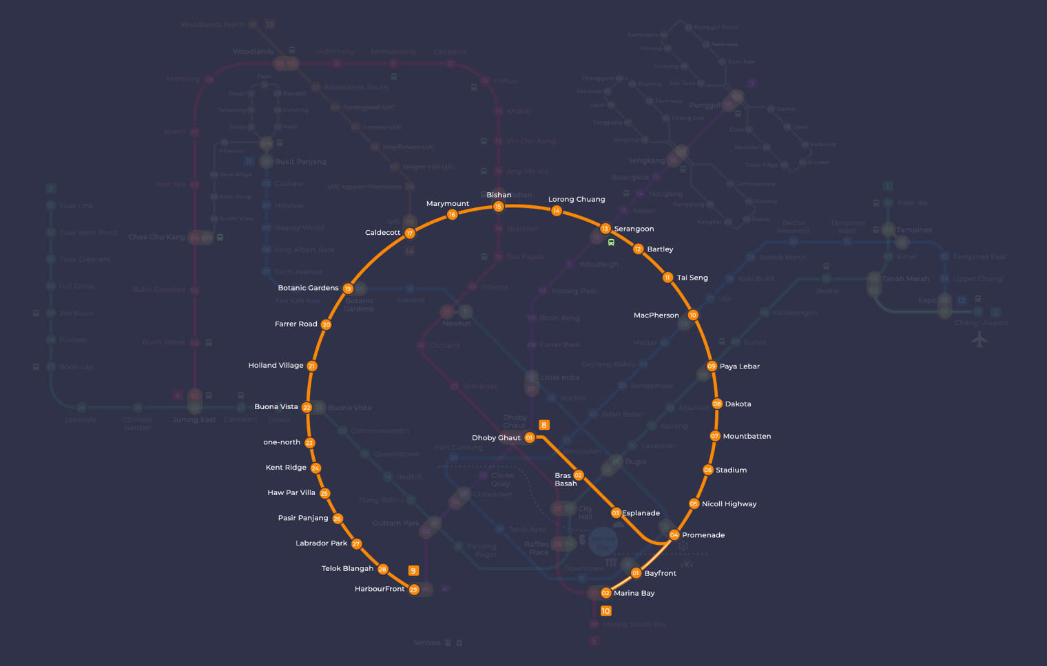
Mountbatten station at a glance
| Station codes | CC7 |
|---|---|
| Lines | Circle Line |
| Interchange | No, single line station |
| Chinese name | 蒙巴登 |
| Tamil name | மவுண்ட்பேட்டன் |
| Next stations | |
| Train times | Circle Line: first train leaves the terminus at 5:37 AM, last train 11:50 PM Full first and last train guide |
See Mountbatten on the map. The interactive map opens with this station highlighted, so you can trace the route from where you are.
From Mountbatten, you can ride one stop to Stadium station (CC6) towards the west, or one stop to Dakota station (CC8) towards the east. Stadium station connects you directly to the Singapore Sports Hub area, while Dakota gives access to the Geylang Kallang district. The Circle Line itself links to multiple interchange stations further along, including Paya Lebar, Dhoby Ghaut, and Bayfront, making transfers to other lines straightforward once you are on the network.
The surrounding neighbourhood is a calm, primarily residential one, made up of older housing estates and tree-lined streets. While there are no major tourist attractions immediately beside the station, the area offers a local, everyday character with coffee shops and small shops within easy walking distance. Passengers heading to the Singapore Sports Hub can also use this station as a convenient alternative entry point, as the venue is reachable with a short walk.
Around Mountbatten station
Mountbatten station sits in a mixed residential and recreational neighbourhood close to the Kallang River. The area is well known for local food, with the Kallang Estate Fresh Market and Food Centre serving the surrounding community. Sports and leisure facilities are also a feature of the district, including the Kallang Squash and Tennis Centre and, further along, the National Stadium.
| Place | Type | Distance | Why go |
|---|---|---|---|
| Kallang Estate Fresh Market and Food Centre | Market / hawker centre | About 220 m (~4 min walk) | Visit for fresh produce and a wide variety of local hawker food stalls. |
| Local Handmade Pau | Food centre | About 380 m (~6 min walk) | Head here for traditional handmade pau and other local snacks. |
| Hock Lam Street Popular Beef Kway Teow | Food centre | About 380 m (~6 min walk) | A popular spot for beef kway teow and classic Singapore hawker dishes. |
| Kallang Squash & Tennis Centre | Sports centre | About 400 m (~7 min walk) | Suitable for squash and tennis sessions in a dedicated sports facility. |
| Old Airport Road Food Centre & Shopping Mall | Shopping mall | About 440 m (~7 min walk) | A combined food centre and shopping destination with many dining and retail options. |
| Leisure Park Kallang | Shopping mall | About 790 m (~13 min walk) | Offers a range of retail shops, dining outlets and leisure activities. |
| National Stadium | Stadium | About 920 m (~15 min walk) | A large venue that hosts major sporting events and concerts. |
| Kallang Wave Mall | Shopping mall | About 1070 m (~17 min walk) | A shopping mall with retail and dining options near the sports hub area. |
Places and straight-line distances from OpenStreetMap data (© OpenStreetMap contributors). Actual walking routes may be longer.
How to get to Mountbatten by MRT
Worked out from the network map. Stop counts are station to station and do not include walking or waiting time.
| From Changi Airport | Take the East West Line from Changi Airport to Paya Lebar (6 stops), then change to the Circle Line from Paya Lebar to Mountbatten (2 stops). About 8 stops with 1 change. |
|---|---|
| From Orchard | Take the North South Line from Orchard to Newton (1 stop), then change to the Downtown Line from Newton to Promenade (4 stops), then change to the Circle Line from Promenade to Mountbatten (3 stops). About 8 stops with 2 changes. |
| From City Hall | Take the East West Line from City Hall to Paya Lebar (5 stops), then change to the Circle Line from Paya Lebar to Mountbatten (2 stops). About 7 stops with 1 change. |
| From Jurong East | Take the East West Line from Jurong East to Buona Vista (3 stops), then change to the Circle Line from Buona Vista to Mountbatten (14 stops). About 17 stops with 1 change. |
| From Woodlands | Take the North South Line from Woodlands to Bishan (8 stops), then change to the Circle Line from Bishan to Mountbatten (8 stops). About 16 stops with 1 change. |
| From HarbourFront | Take the North East Line from HarbourFront to Chinatown (1 stop), then change to the Downtown Line from Chinatown to Promenade (4 stops), then change to the Circle Line from Promenade to Mountbatten (3 stops). About 8 stops with 2 changes. |
Tips for using Mountbatten station
- Kallang Estate Fresh Market and Food Centre is an easy short walk from the station, making it a convenient stop for a meal or grocery run.
- Old Airport Road Food Centre and Shopping Mall is roughly a seven-minute walk and worth the short journey for its wide hawker selection.
- Leisure Park Kallang and Kallang Wave Mall are further away at around 13 to 17 minutes on foot, so you may prefer to take a bus or ride to reach them comfortably.
- During major events at the National Stadium, expect higher passenger volumes at the station, so allow extra time for your journey.
All stations on the Circle Line
In order along the line, with Mountbatten marked. Stations with their own guide are linked.
| Code | Station | Interchange |
|---|---|---|
| CC2 | Bras Basah | – |
| CC3 | Esplanade | – |
| CC4 | Promenade | CC / DT |
| CC5 | Nicoll Highway | – |
| CC6 | Stadium | – |
| CC7 | Mountbatten (you are here) | – |
| CC8 | Dakota | – |
| CC9 | Paya Lebar | CC / EW |
| CC10 | MacPherson | CC / DT |
| CC11 | Tai Seng | – |
| CC12 | Bartley | – |
| CC13 | Serangoon | CC / NE |
| CC14 | Lorong Chuan | – |
| CC15 | Bishan | NS / CC |
| CC16 | Marymount | – |
| CC17 | Caldecott | CC / TE |
| CC19 | Botanic Gardens | DT / CC |
| CC20 | Farrer Road | – |
| CC21 | Holland Village | – |
| CC22 | Buona Vista | EW / CC |
| CC23 | one-north | – |
| CC24 | Kent Ridge | – |
| CC25 | Haw Par Villa | – |
| CC26 | Pasir Panjang | – |
| CC27 | Labrador Park | – |
| CC28 | Telok Blangah | – |
| CC29 | HarbourFront | CC / NE |
Read the full Circle Line guide.
Mountbatten station: common questions
Which line is Mountbatten MRT station on?
Mountbatten is on the Circle Line. Its station code is CC7.
Is Mountbatten an interchange station?
No. Mountbatten is served by the Circle Line only. The nearest interchange is shown in the next stations row above.
What time is the first and last train at Mountbatten?
Times below are for the first and last train leaving the line terminus; trains reach Mountbatten a few minutes later depending on its position on the line. Circle Line first train 5:37 AM, last train 11:50 PM. Check the operator for holiday changes.
What is near Mountbatten MRT station?
The station is close to several hawker centres including Kallang Estate Fresh Market and Food Centre, as well as the Kallang Squash and Tennis Centre and Old Airport Road Food Centre and Shopping Mall. Further away you will find Leisure Park Kallang, the National Stadium and Kallang Wave Mall.
Which food centre or mall is closest to Mountbatten station?
Kallang Estate Fresh Market and Food Centre is the closest, at approximately 220 metres and around a four-minute walk from the station.
How far is the National Stadium from Mountbatten MRT station?
The National Stadium is approximately 920 metres away in a straight line, which is roughly a 15-minute walk.
How do I get to Mountbatten from Changi Airport by MRT?
Take the East West Line from Changi Airport to Paya Lebar (6 stops), then change to the Circle Line from Paya Lebar to Mountbatten (2 stops). About 8 stops with 1 change.
Sources: station codes, line colours and interchanges from the LTA rail system map; operating hours from SMRT and SBS Transit. Last reviewed September 2026.
Plan the rest of the trip
Every station on the Circle Line is listed on its line guide, with the full route and interchanges. For times, see the first and last train guide, and for the whole network in one view use the interactive Singapore MRT map or the PDF map.