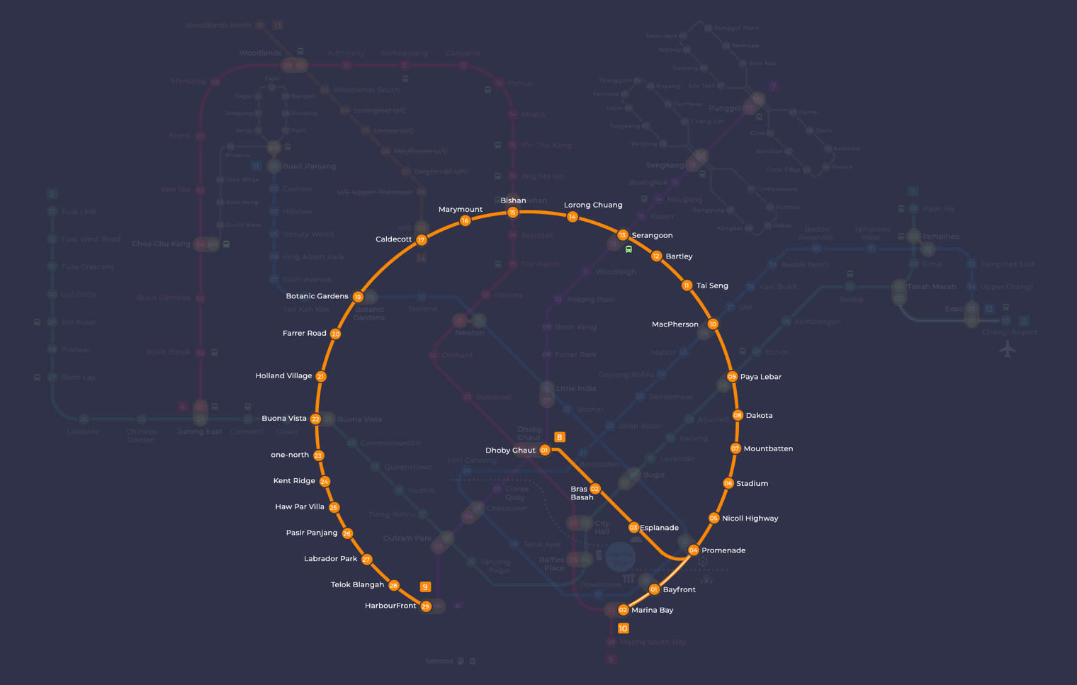
yellow line mrt highlighted. For searching and highlighting MRT stations or lines on the map we recommend to use our interactive MRT map.
About the Circle Line
The Circle Line, sometimes called the Yellow Line, is a fully automated, driverless MRT line that forms a complete loop around the city. It opened in stages from 2009, with the most recent addition, Stage 6, opening on 12 July 2026. That final stretch added three stations connecting HarbourFront to Marina Bay, closing the loop for the first time.
What is the Circle Line and where does it go?
The Circle Line runs for about 39.5 km and serves 33 stations. It covers major residential and commercial areas including Bishan, Serangoon, and Paya Lebar, and now forms a continuous loop so trains run in both directions around the ring.
Because it is a loop line, you can board in either direction to reach your destination, which is useful if one direction is more congested than the other. It also means the line connects well to itself: if you overshoot a station, you can stay on and arrive from the other side.
The Circle Line interchanges with every other MRT line in the network, including the North South Line at Bishan and Dhoby Ghaut, the East West Line at Paya Lebar and Buona Vista, the North East Line at Serangoon, Dhoby Ghaut and HarbourFront, the Downtown Line at Botanic Gardens, Caldecott and Promenade, and the Thomson-East Coast Line at Caldecott and Gardens by the Bay.
Your Insider’s Guide to the Circle Line MRT: Routes, Stations, and More
Singapore’s Circle Line (CCL) is one of the most important MRT lines in the city-state and forms an integral part of its extensive public transport system. The fully automated underground line links many parts of Singapore and has significantly enhanced access and shorten journey times for millions commuting by train. The article will take you through the history, construction, and route alignment of Circle Line MRT along with its important stations, passenger experience, technological lift-ups, as well prospects. As a resident or visitor, your degree of understanding regarding Circle Line MRT will ensure smooth navigation in and around Singapore.
1. Introduction
Singapore’s Circle Line (CCL) occupies a unique place in the island state as one of its important MRT lines complete circle that encircles the central region. Covering about 39.5 km with 33 stations, the CCL serves various commuters by passing through their residential areas, business districts and educational institutions as well as recreational facilities. The line with orange stripes on the Singapore MRT Map is an automated driverless transit system. The Circle Line MRT has improved the connectivity and convenience of public transport in Singapore, enabling residents and visitors to travel around any part of the city with great ease.
2. History and Development Circle Line MRT
Origins and Planning
Planning for the Circle Line dates back to the early 1990s, when the Land Transport Authority decided Singapore needed a route that would link areas not directly served by the existing radial lines. The goal was to improve connectivity across the network and ease congestion on the North South and East West Lines. Running the line entirely underground kept land acquisition to a minimum and reduced disruption during construction.
Phased Construction and Milestones
The Circle Line was built in stages, so sections could open to commuters while work continued elsewhere. Construction spanned over 17 years from the first opening to the completed loop.
Stage 3 (opened 28 May 2009): Bartley to Marymount, 5 stations. This was the first section to open.
Stages 1 and 2 (opened 17 April 2010): Dhoby Ghaut to Bartley, 11 stations including Esplanade, Promenade, Stadium and Paya Lebar.
Stages 4 and 5 (opened 8 October 2011): Marymount to HarbourFront, 12 stations including Botanic Gardens, Buona Vista, one-north and Labrador Park.
Circle Line Extension (opened 14 January 2012): Promenade to Bayfront and Marina Bay, 2 stations.
Stage 6 (opened 12 July 2026): HarbourFront to Marina Bay via Keppel (CC30), Cantonment (CC31) and Prince Edward Road (CC32), 3 stations. This closed the loop, making the Circle Line a full circle for the first time.
3. Route and Key Stations
Overview of the Circle Line MRT Route
The Circle Line runs a full loop around central Singapore, covering about 39.5 km across 33 stations. It connects major residential districts, the central business district and key leisure areas before looping back on itself, giving you a direct way to travel around the city without always heading into the centre first.
The line intersects every other MRT line at one point or another, making it one of the most useful for transfers. If you want an overview of how it fits into the broader network, the Singapore MRT lines guide covers all lines in one place. Connecting to the Downtown Line is also straightforward at several points along the route.
The Circle Line has several interchange stations that connect you directly to other lines. These are the key ones worth knowing:
Dhoby Ghaut (CC1): A three-line interchange where the Circle Line meets the North South Line and the North East Line. It sits at the top of Orchard Road and is one of the busiest transfer points on the network.
Bishan (CC15): An interchange with the North South Line, serving a large residential and commercial catchment. Bishan is a major node for commuters heading north or south.
Paya Lebar (CC9): An interchange with the East West Line, sitting in a mixed commercial and residential area. The station gives you easy access to the Paya Lebar Quarter and surrounding business parks.
Serangoon (CC13): An interchange with the North East Line, serving the northeastern residential estates and the shopping malls in the Serangoon area.
Buona Vista (CC22): An interchange with the East West Line, close to the National University of Singapore and the Biopolis research cluster. A useful stop if you are heading to the one-north precinct.
The Circle Line passes through or near some of Singapore’s most visited spots. Here are a few worth knowing.
Esplanade (CC3): This station gives you direct access to Singapore’s cultural district. The Esplanade Theatres on the Bay is right on your doorstep, and Marina Bay Sands is a short walk away.
Bayfront (CE1/DT16): Alight here for Marina Bay Sands, Gardens by the Bay and the bars and restaurants along Marina Gardens Drive. It is an interchange with the Downtown Line.
Botanic Gardens (CC19): The Singapore Botanic Gardens is a UNESCO World Heritage Site, and this station puts you right at its entrance. A good escape from the city on any day of the week.
Stadium (CC6): Use this station for Singapore Sports Hub, including the National Stadium for major sporting events and concerts. Kallang Wave Mall is also here if you want to eat or shop before or after.
Kent Ridge (CC24): This station serves the National University of Singapore campus and is close to Kent Ridge Park, a popular spot for hiking and nature walks.
4. The Role of the Circle Line MRT in Singapore’s Transit Network
Enhancing Connectivity
The Circle Line was designed to improve connections across the island, particularly for areas that radial lines do not serve directly. It loops around the city centre, links the major MRT lines at interchange stations and reduces the need to travel through the city centre to get from one side of Singapore to the other. This takes pressure off the busier downtown sections of other lines, especially during peak hours.
Because so many interchange stations are spread around the loop, transferring between lines is straightforward. That makes the Circle Line a practical backbone of the network for anyone making cross-town journeys without going through the city centre first.
The Circle Line cuts travel times for many cross-town trips by letting you bypass the city centre entirely. Instead of heading into the city and transferring, you can ride directly between suburban stations on a single line.
The journey from HarbourFront to Paya Lebar, which once required at least two transfers on other lines, takes about 30 minutes on the CCL. Bishan to Buona Vista, previously around 40 minutes, now takes roughly 20.
Economic and Social Links
The Circle Line connects residential neighbourhoods directly to business districts, universities, hospitals and leisure destinations. That makes it easier for people to reach work, study and recreation without long detours through the city centre.
Better connectivity has encouraged development along the CCL corridor, with residential and commercial projects following the improved access. New stations typically attract businesses and investment to their surrounding areas, and the CCL is no different.
5. Technology and Design
➡️ Automated Operations and Safety Features
All Circle Line services run on a fully automated, driverless system using Communications-Based Train Control (CBTC). This lets trains run at the best possible speeds while keeping safe gaps between them. During peak hours the line can run tighter headways, then ease off during quieter periods to manage passenger flow efficiently.
Every station has platform screen doors, which prevent passengers from falling onto the tracks and help maintain a comfortable temperature on the platforms. Trains also carry emergency intercoms so you can reach staff quickly if you need help. The line is monitored by CCTV cameras throughout, allowing any issues to be dealt with promptly. For a comparable automated light rail setup, see the Punggol LRT guide.
Circle Line stations were designed with three broad goals in mind: functionality, aesthetics, and a sense of place. Each station was meant to be more than a transfer point, serving as a small landmark in its own neighbourhood.
Esplanade Station (CC3): The design draws on the surrounding arts precinct, with references to Singapore’s performing arts scene worked into the station’s interiors.
Bras Basah Station (CC2): A glass-topped pool on the concourse level lets natural light filter down to the platform, giving the station a distinctly open feel during daylight hours.
Botanic Gardens Station (CC19): Sitting close to the UNESCO World Heritage-listed Singapore Botanic Gardens, the station uses nature-inspired patterns and greenery in its design to echo the landscape just outside.
Throughout the line, station interiors are built to handle large crowds comfortably, with clear layouts and good sightlines. The materials and systems used are chosen for durability, ease of maintenance, and energy efficiency.
Environmental Sustainability
The Circle Line was designed with a number of green features to reduce the environmental impact of MRT operations and support Singapore’s broader sustainability goals.
The stations use energy-saving LED lighting throughout, and the trains employ regenerative braking, which converts kinetic energy back into electricity and feeds it into the power grid. Some stations also make use of natural ventilation and daylighting to reduce reliance on mechanical air-conditioning.
Rainwater harvesting systems at certain stations capture water for non-potable uses such as cleaning and irrigation. Landscaping around the stations favours drought-resistant plants to keep water consumption down.
Recycled and locally sourced materials were used in construction wherever practical, and efforts were made to minimise waste both during building and in day-to-day operations.
6. Commuter Experience
Ease of Use and Accessibility
Getting around on the Circle Line is straightforward. Every station has clear bilingual signage pointing you to platforms, exits and interchange connections, and escalators, staircases and lifts are positioned to keep passenger flow moving.
Accessibility is taken seriously across the line. All stations have barrier-free access, including ramps and tactile guide paths for visually impaired commuters. Train doors and aisles are wide enough for wheelchairs, prams and mobility scooters, and priority seats are available for elderly passengers, pregnant women and those who need them.
Passenger Comfort and Safety
Circle Line trains are air-conditioned, which you will appreciate the moment you step on board in Singapore’s heat. Seats are comfortable and the carriages are spacious enough to handle busy peak-hour loads. In-carriage and in-station announcements tell you the next station, transfer options and any service updates as you go.
Safety features are built into every station: platform screen doors keep you away from the track edge, CCTV covers the platforms and trains, and emergency communication panels are positioned throughout. Fire safety equipment is in place at every station, and the line undergoes regular maintenance checks and emergency drills.
Stations and trains are kept to a high standard of cleanliness, which is consistent with what you will find across the Singapore MRT network generally. For daily commuters, that makes the experience noticeably more pleasant.
Integration with Other Transport Modes
The Circle Line connects directly to every other MRT line in Singapore at various interchange stations, so switching lines is straightforward without leaving the fare gates at those points. Interchanges include busy stations such as Dhoby Ghaut, Paya Lebar, Bishan, Serangoon and Harbourfront, among others.
Most Circle Line stations also have bus stops close by, and some are adjacent to major bus interchanges, making it easy to complete your journey by bus if you need to. Taxi and ride-hailing pick-up points are available at the larger stations as well.
7. Future Works and Extensions
Stage 6 is open: the loop is complete
Circle Line Stage 6 opened on 12 July 2026, after a public preview on 4 July. Its three new underground stations, Keppel (CC30), Cantonment (CC31) and Prince Edward Road (CC32), link HarbourFront to Marina Bay. Trains now run clockwise and anticlockwise around the full loop, so trips between the southern waterfront and Marina Bay no longer need a change at Dhoby Ghaut or Outram Park. Read more in our Circle Line Stage 6 guide.
The area around Keppel and Cantonment is being redeveloped as part of the Greater Southern Waterfront, so these stations will serve new homes and offices over the coming years.
Potential Future Stations and Routes
With the loop now complete, there is no confirmed plan to extend the Circle Line further. LTA reviews Singapore’s transport needs regularly, so infill stations or short extensions remain possible if population growth or new developments justify them. Any future additions would be announced well in advance, so keep an eye on official LTA updates.
Impact on Singapore’s Urban Landscape
Stage 6 fills a genuine gap in the network, giving the southern waterfront direct rail access and reducing reliance on interchanges. The Greater Southern Waterfront redevelopment will bring more residents and workplaces to Keppel and Cantonment over the coming years, and the Circle Line is well placed to support that growth. A full rail loop around the city fringe also supports Singapore’s long-term goal of making public transport the first choice over driving.
8. Summary
The Circle Line is now a full loop of 33 stations and about 39.5 km. Stage 6 opened in July 2026, closing the final gap between HarbourFront and Marina Bay and connecting several neighbourhoods and lines that had limited rail options before.
For everyday commuters, the orange line cuts out a lot of unnecessary backtracking through the city centre. Visitors find it just as useful for getting between places like Botanic Gardens, Dhoby Ghaut, Esplanade and HarbourFront without changing lines repeatedly.
Operated by SMRT, the Circle Line is a practical part of getting around Singapore, and with the full loop now in place, it is more useful than it has ever been.
Is the Circle Line the yellow line or the orange line?
Both. The LTA prints the Circle Line in orange on the system map, but commuters in Singapore almost always call it the yellow line. It is the same line, with station codes CC1 to CC34 plus CE1 and CE2.
Who operates the Circle Line MRT?
SMRT operates the Circle Line. It also runs the North South Line, East West Line, Thomson-East Coast Line and Bukit Panjang LRT.
When did the Circle Line become a full loop?
The Circle Line completed its loop on 12 July 2026, when Stage 6 opened with three new stations: Keppel (CC30), Cantonment (CC31) and Prince Edward Road (CC32). A public preview ran from 4 July 2026 before the official opening.
How many stations does the Circle Line have?
The Circle Line has 33 stations across about 39.5 km. That count includes Bayfront (CE1) and Marina Bay (CE2), which now sit on the loop itself rather than on a short spur.
Does the Thomson-East Coast Line interchange with the Circle Line?
Yes. You can change between the two lines at Caldecott (CC17 and TE9) and at Marina Bay (CE2 and TE20). Caldecott is handy for trips between the north and the western half of the loop without going into the city centre.
How do I pay for the Circle Line MRT?
You can pay with an EZ-Link or SimplyGo card, a contactless bank card or a mobile wallet. If you are visiting Singapore, a Singapore Tourist Pass is also available and works across all MRT and LRT lines.
Want the whole route on one page? Open the Circle Line map to see every station and interchange along the line.