
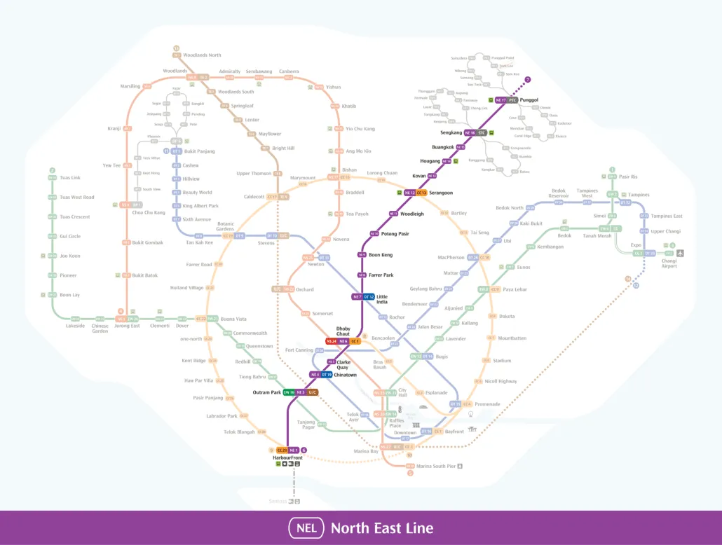
Full North East Line guide: every station, interchange and the route in one place.
This North East Line map shows the full purple route of the NE line, running from HarbourFront (NE1) on the southern waterfront to Punggol Coast (NE18) in the far north east. Every station is marked with its NE code, and the interchange stops where you can change to other MRT lines or the Sengkang and Punggol LRT systems are clearly flagged. As of October 2026 there are 17 open stations on the line. It is one of the simplest lines in Singapore to follow, with a single route and no branches.
About the image: The map image above dates from 2022, before Punggol Coast (NE18) opened on 10 December 2024. The station table further down this page is up to date.
How to read the North East Line map
The line is drawn in purple, which is why many riders simply call it the purple line. Each station carries a code made up of the letters NE and a number. The numbers rise as you travel north, starting at NE1 HarbourFront and finishing at NE18 Punggol Coast. If you want to know how purple fits alongside the other lines, our guide to Singapore MRT line colours sets them all out.
You will notice there is no NE2 on the map. The numbering jumps straight from NE1 HarbourFront to NE3 Outram Park, so the gap is part of the code sequence rather than a missing stop you need to look for. No station along the open route is shown as unopened.
Interchange stations are drawn with a larger marker that joins the purple line to the colour of the connecting line, with the other line’s station code printed alongside. At Sengkang and Punggol, the codes STC and PTC refer to the LRT stations that serve the surrounding estates.
The North East Line itself has no branch or loop. It is one continuous line from end to end. The loops you see near its northern end belong to the Sengkang LRT and Punggol LRT, each of which runs an East Loop and a West Loop from its hub station on the NE line.
Getting around Singapore? Find any station on the interactive MRT map, or save the PDF map to use offline.
Route and stations along the line
The line begins at HarbourFront (NE1), where it meets the Circle Line. Heading north, the next stop is Outram Park (NE3), a three line interchange with the East West Line and the Thomson East Coast Line. From there the line runs underground through the city centre: Chinatown (NE4) for the Downtown Line, Clarke Quay (NE5) beside the Singapore River, and then Dhoby Ghaut (NE6), one of the busiest interchanges on the network, linking to both the North South Line and the Circle Line.
Beyond Dhoby Ghaut the line follows the Serangoon corridor. Little India (NE7) offers another change to the Downtown Line, followed by Farrer Park (NE8), Boon Keng (NE9), Potong Pasir (NE10) and Woodleigh (NE11). At Serangoon (NE12) you can join the Circle Line again, which is handy for reaching the northern half of the loop without going back through the city.
The final stretch serves the north eastern housing estates. After Kovan (NE13), Hougang (NE14) and Buangkok (NE15), the line reaches Sengkang (NE16) and Punggol (NE17), both of which connect to their own LRT networks. The line now ends at Punggol Coast (NE18), the newest station, which opened on 10 December 2024. To see how this route connects with the rest of Singapore, open our interactive MRT map.
Where to change lines
- HarbourFront (NE1): change to the Circle Line (CC29)
- Outram Park (NE3): change to the Thomson East Coast Line (TE17) and East West Line (EW16)
- Chinatown (NE4): change to the Downtown Line (DT19)
- Dhoby Ghaut (NE6): change to the North South Line (NS24) and Circle Line (CC1)
- Little India (NE7): change to the Downtown Line (DT12)
- Serangoon (NE12): change to the Circle Line (CC13)
- Sengkang (NE16): change to the Sengkang LRT (STC)
- Punggol (NE17): change to the Punggol LRT (PTC)
With the Circle Line loop closed in July 2026 by the opening of Keppel, Cantonment and Prince Edward Road, the three Circle Line interchanges at HarbourFront, Dhoby Ghaut and Serangoon give you more ways round the city than before. Before you travel, check the fares and fare calculator for your journey.
How the line grew
A line serving Punggol and Jalan Kayu was first proposed in September 1984, and in December that year a British consultancy team was appointed to study possible routes. By March 1986 a tentative route from Outram Park to Punggol had been drawn up, connecting with the existing system at Dhoby Ghaut and running through Hougang. The project was approved in October 1986 and accepted by the government “in principle” in January 1989. Construction was held back, however, while the Woodlands extension took priority.
A white paper on 2 January 1996 recommended building the line earlier to ease congestion in the north east, and on 19 January the government announced it would go ahead “immediately”. The 16 original stations were announced on 4 March 1996. Potong Pasir (then named Sennett), Woodleigh and Punggol were at first planned as shell stations, but it was later decided to complete them in full. Construction began with a groundbreaking ceremony at Farrer Park on 25 November 1997, and on 20 May 1999 SBS Transit was appointed to run the line together with the Sengkang and Punggol LRT.
The most recent addition is Punggol Coast (NE18), which opened on 10 December 2024 and extended the line beyond Punggol. For timings, exits and station by station details, see our full North East Line guide.
North East Line map: every station
Every station on the map in order, with its code and the lines you can change to. Station names link to our full station guides.
| Code | Station | Change to |
|---|---|---|
| NE1 | HarbourFront | CC29 |
| NE3 | Outram Park | TE17, EW16 |
| NE4 | Chinatown | DT19 |
| NE5 | Clarke Quay | |
| NE6 | Dhoby Ghaut | NS24, CC1 |
| NE7 | Little India | DT12 |
| NE8 | Farrer Park | |
| NE9 | Boon Keng | |
| NE10 | Potong Pasir | |
| NE11 | Woodleigh | |
| NE12 | Serangoon | CC13 |
| NE13 | Kovan | |
| NE14 | Hougang | |
| NE15 | Buangkok | |
| NE16 | Sengkang | STC |
| NE17 | Punggol | PTC |
| NE18 | Punggol Coast |
Frequently asked questions
Is the purple line the North East Line?
Yes. The North East Line is shown in purple on Singapore MRT maps, and its stations use the code NE. It runs from HarbourFront (NE1) to Punggol Coast (NE18).
How many stations are on the NE line?
There are 17 open stations as of October 2026. The codes run from NE1 to NE18, but there is no NE2 on the map, so the count is one fewer than the highest number.
Where can I change lines on the North East Line?
There are eight interchanges: HarbourFront, Outram Park, Chinatown, Dhoby Ghaut, Little India and Serangoon for other MRT lines, plus Sengkang and Punggol for the LRT. Dhoby Ghaut and Outram Park each connect to two other lines.
Can I download a North East Line map?
You can save the map image at the top of this page, or download our MRT map PDF, which shows the North East Line alongside the whole network. If you are not sure which purple line station is closest to you, try our nearest station finder.
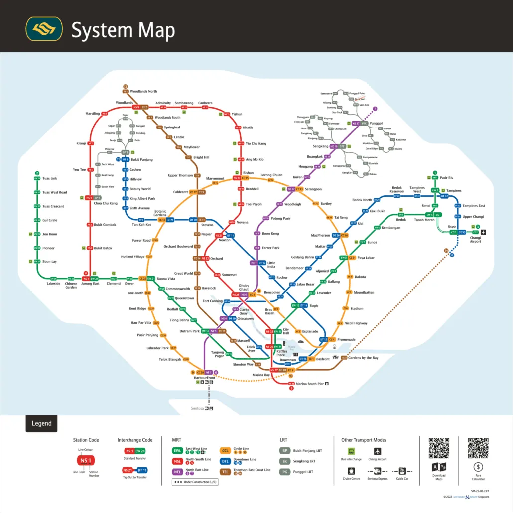
For the official version, see the LTA rail network map.