
Bayshore MRT Station
Bayshore MRT station (TE29) is a station on the Thomson-East Coast Line serving the Bayshore residential area along the eastern coast of Singapore. It is not an interchange station. The station sits within a largely residential district near the East Coast, catering primarily to those living in the surrounding housing developments and nearby coastal precinct.
Bayshore on the Thomson East Coast Line map
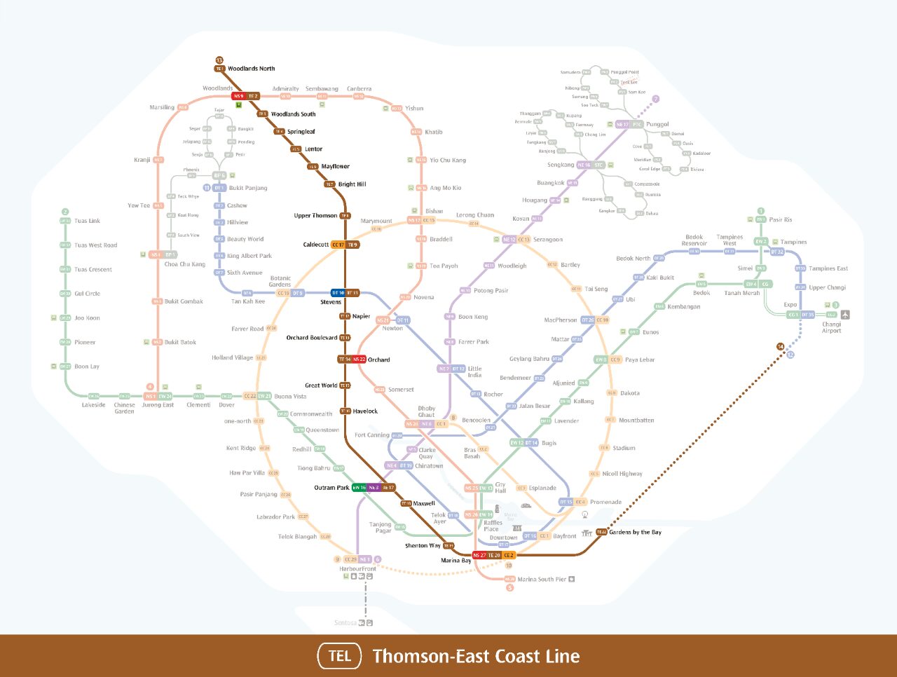
Bayshore station at a glance
| Station codes | TE29 |
|---|---|
| Lines | Thomson East Coast Line |
| Interchange | No, single line station |
| Chinese name | 碧湾 |
| Tamil name | பேஷோர் |
| Next stations | |
| Train times | Thomson East Coast Line: first train leaves the terminus at 5:36 AM, last train 11:27 PM Full first and last train guide |
See Bayshore on the map. The interactive map opens with this station highlighted, so you can trace the route from where you are.
From Bayshore, passengers can travel along the Thomson-East Coast Line to reach destinations across Singapore, from the city centre to the northern regions. The neighbouring station is Siglap (TE28), which connects onward towards the rest of the line. As this is not an interchange, travellers needing other lines will need to continue to a connecting station elsewhere on the Thomson-East Coast Line.
The station is situated close to East Coast Park, a long stretch of parkland and beach along the shoreline that is popular for cycling, picnicking, and recreational activities. The surrounding neighbourhood is a low-rise residential area with a quieter, coastal character, making the station useful mainly for residents of the Bayshore and Upper East Coast districts and visitors heading to the park and seafront.
Around Bayshore station
Bayshore station sits within a largely residential neighbourhood on the eastern coast of Singapore, surrounded by housing estates and open recreational spaces. East Coast Park is close by, making the area popular with cyclists, joggers and beachgoers. Siglap Community Centre serves the local community nearby, reflecting the settled, family-oriented character of the district.
| Place | Type | Distance | Why go |
|---|---|---|---|
| Siglap Community Centre | Community club | About 460 m (~7 min walk) | Visit Siglap Community Centre for community programmes, sports facilities and local activities. |
| Kopitiam | Food centre | About 580 m (~9 min walk) | Head to Kopitiam for a convenient hawker-style meal with a range of local food options. |
| East Coast Park (Zone F) | Park | About 590 m (~10 min walk) | East Coast Park (Zone F) is ideal for outdoor recreation, cycling and seaside leisure. |
| Airfield Restaurant | Food centre | About 610 m (~10 min walk) | Airfield Restaurant offers a casual dining option a short distance from the station. |
| Kew Crescent Playground | Park | About 750 m (~12 min walk) | Kew Crescent Playground is a neighbourhood play area suited to families with young children. |
| Sennett Avenue Playground | Park | About 860 m (~14 min walk) | Sennett Avenue Playground provides another local outdoor space for recreation and leisure. |
| Upper East Coast Terminal | Bus interchange | About 1050 m (~17 min walk) | Upper East Coast Terminal is a bus interchange connecting passengers to wider parts of Singapore. |
Places and straight-line distances from OpenStreetMap data (© OpenStreetMap contributors). Actual walking routes may be longer.
How to get to Bayshore by MRT
Worked out from the network map. Stop counts are station to station and do not include walking or waiting time.
| From Changi Airport | Take the East West Line from Changi Airport to Outram Park (14 stops), then change to the Thomson East Coast Line from Outram Park to Bayshore (11 stops). About 25 stops with 1 change. |
|---|---|
| From Orchard | Take the Thomson East Coast Line from Orchard to Bayshore (14 stops). About 14 stops, no changes. |
| From City Hall | Take the East West Line from City Hall to Outram Park (3 stops), then change to the Thomson East Coast Line from Outram Park to Bayshore (11 stops). About 14 stops with 1 change. |
| From Jurong East | Take the East West Line from Jurong East to Outram Park (8 stops), then change to the Thomson East Coast Line from Outram Park to Bayshore (11 stops). About 19 stops with 1 change. |
| From Woodlands | Take the Thomson East Coast Line from Woodlands to Bayshore (24 stops). About 24 stops, no changes. |
| From HarbourFront | Take the Circle Line from HarbourFront to Marina Bay (4 stops), then change to the Thomson East Coast Line from Marina Bay to Bayshore (8 stops). About 12 stops with 1 change. |
Tips for using Bayshore station
- East Coast Park, Kopitiam and Airfield Restaurant are all within roughly 10 minutes on foot, so walking is a reasonable option for most visitors.
- Upper East Coast Terminal is approximately 17 minutes on foot, so taking a bus from stops near the station may save time if you are heading there.
- Allow extra time during morning and evening peak hours, as trains on the Thomson East Coast Line can be busier and platform waiting times may increase.
- If you plan to visit multiple spots such as East Coast Park and nearby food options in one trip, it helps to plan your route in advance as the places are spread across different directions from the station.
All stations on the Thomson East Coast Line
In order along the line, with Bayshore marked. Stations with their own guide are linked.
| Code | Station | Interchange |
|---|---|---|
| TE1 | Woodlands North | – |
| TE2 | Woodlands | NS / TE |
| TE3 | Woodlands South | – |
| TE4 | Springleaf | – |
| TE5 | Lentor | – |
| TE7 | Bright Hill | – |
| TE8 | Upper Thomson | – |
| TE9 | Caldecott | CC / TE |
| TE11 | Stevens | DT / TE |
| TE12 | Napier | – |
| TE13 | Orchard Boulevard | – |
| TE14 | Orchard | TE / NS |
| TE15 | Great World | – |
| TE16 | Havelock | – |
| TE17 | Outram Park | TE / EW |
| TE18 | Maxwell | – |
| TE19 | Shenton Way | – |
| TE20 | Marina Bay | CE / TE |
| TE22 | Gardens by the Bay | – |
| TE23 | Tanjong Rhu | – |
| TE24 | Katong Park | – |
| TE25 | Tanjong Katong | – |
| TE26 | Marine Parade | – |
| TE27 | Marine Terrace | – |
| TE28 | Siglap | – |
| TE29 | Bayshore (you are here) | – |
Read the full Thomson East Coast Line guide.
Bayshore station: common questions
Which line is Bayshore MRT station on?
Bayshore is on the Thomson East Coast Line. Its station code is TE29.
Is Bayshore an interchange station?
No. Bayshore is served by the Thomson East Coast Line only. The nearest interchange is shown in the next stations row above.
What time is the first and last train at Bayshore?
Times below are for the first and last train leaving the line terminus; trains reach Bayshore a few minutes later depending on its position on the line. Thomson East Coast Line first train 5:36 AM, last train 11:27 PM. Check the operator for holiday changes.
What is near Bayshore MRT station?
Nearby places include Siglap Community Centre, Kopitiam, East Coast Park (Zone F), Airfield Restaurant, Kew Crescent Playground, Sennett Avenue Playground and Upper East Coast Terminal, all within approximately 1,100 metres of the station.
Which food centre is closest to Bayshore MRT station?
Kopitiam is the closest food centre, at approximately 580 metres straight-line distance, which is roughly a 9-minute walk.
How far is East Coast Park from Bayshore MRT station?
East Coast Park (Zone F) is approximately 590 metres away in a straight line, which is roughly a 10-minute walk from the station.
How do I get to Bayshore from Changi Airport by MRT?
Take the East West Line from Changi Airport to Outram Park (14 stops), then change to the Thomson East Coast Line from Outram Park to Bayshore (11 stops). About 25 stops with 1 change.
Sources: station codes, line colours and interchanges from the LTA rail system map; operating hours from SMRT and SBS Transit. Last reviewed September 2026.
News and guides mentioning Bayshore
- Upper Changi Homes Near MRT: URA Reviews Density Limits 23 Sep 2026
- Best MRT Routes for Marina Bay Sands & Gardens 5 May 2026
- MRT Map Singapore 2026: What Is New Since 2024 16 Aug 2024
- Singapore MRT Map PDF 2026 30 Jan 2024
Plan the rest of the trip
Every station on the Thomson East Coast Line is listed on its line guide, with the full route and interchanges. For times, see the first and last train guide, and for the whole network in one view use the interactive Singapore MRT map or the PDF map.