
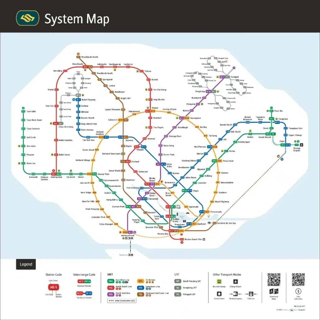
The Singapore MRT map has changed more since 2024 than in any two-year stretch before it. Seven stations opened on the Thomson-East Coast Line, the North East Line reached Punggol Coast, Hume station finally opened on the Downtown Line, and in July 2026 the Circle Line became a full loop. This guide lists every change on the MRT map Singapore since 2024, what is still under construction, and how to use the updated map to plan a trip.
Quick answer: the 2026 MRT map adds Tanjong Rhu to Bayshore on the Thomson-East Coast Line (June 2024), Punggol Coast on the North East Line (December 2024), Hume on the Downtown Line (February 2025) and Keppel, Cantonment and Prince Edward Road on the Circle Line (July 2026). Bedok South and Sungei Bedok are next, due in the second half of 2026.

n
What changed on the MRT map since 2024
| Opened | Line | New stations | What it changed |
|---|---|---|---|
| 23 June 2024 | Thomson-East Coast Line Stage 4 | Tanjong Rhu, Katong Park, Tanjong Katong, Marine Parade, Marine Terrace, Siglap, Bayshore | Direct trains from the East Coast to Marina Bay, Orchard and Woodlands |
| 10 December 2024 | North East Line | Punggol Coast (NE18) | Serves Punggol Digital District and the Singapore Institute of Technology campus |
| 28 February 2025 | Downtown Line | Hume (DT4) | A new stop between Hillview and Beauty World |
| 12 July 2026 | Circle Line Stage 6 | Keppel (CC30), Cantonment (CC31), Prince Edward Road (CC32) | Closes the loop between HarbourFront and Marina Bay |
Getting around Singapore? Find any station on the interactive MRT map, or save the PDF map to use offline.
Thomson-East Coast Line: the East Coast stretch
Stage 4 of the Thomson-East Coast Line opened on 23 June 2024 with seven stations from Tanjong Rhu (TE23) to Bayshore (TE29). On the map it is the brown line running along the East Coast, parallel to Marine Parade Road. For the first time, residents of Katong, Marine Parade and Siglap have a train straight to Marina Bay, Orchard and the north of the island without a bus to the East West Line first.
Founders’ Memorial station, between Gardens by the Bay and Tanjong Rhu, was built but is not yet open, so trains run through it without stopping. The full station list is on the Thomson-East Coast Line map.
North East Line: Punggol Coast
Punggol Coast (NE18) opened on 10 December 2024 as the new end of the purple line, one stop after Punggol. It serves the Punggol Digital District and the new Singapore Institute of Technology campus, and it shortens the walk or bus ride for homes on the northern edge of Punggol town. HarbourFront to Punggol Coast is now the full length of the North East Line.
Downtown Line: Hume station
Hume (DT4) sits between Hillview and Beauty World on the blue line. The station shell was built when the Downtown Line opened in 2015 and it opened for passengers on 28 February 2025. It serves the Hume Avenue estates and is a short walk from the Rail Corridor, which makes it handy for walks and cycling along the old railway route.
Circle Line Stage 6: the loop is complete
The biggest change on the 2026 map is the Circle Line. Stage 6 opened on 12 July 2026, after a public preview on 4 July, with three new underground stations: Keppel (CC30), Cantonment (CC31) and Prince Edward Road (CC32). They link HarbourFront to Marina Bay, so the yellow line is finally a circle.
Trains now run clockwise and anticlockwise around the whole loop. People travelling between the southern waterfront and Marina Bay no longer need to change trains at Dhoby Ghaut or Outram Park. Read the full story in our Circle Line Stage 6 guide.
Opening next: Bedok South and Sungei Bedok
The Land Transport Authority has said Thomson-East Coast Line Stage 5 and the Downtown Line 3 Extension will open in the second half of 2026. Stage 5 adds Bedok South and Sungei Bedok on the brown line after Bayshore. The Downtown Line extension adds Xilin and Sungei Bedok after Expo. Sungei Bedok becomes a new interchange between the two lines. We will add both stations to the map as soon as they open.
Further out: Jurong Region Line and Cross Island Line
- Jurong Region Line: Stage 1 is now expected around mid 2028, later than the original end 2027 target. Interim shuttle buses are planned from end 2027.
- Cross Island Line: Phase 1, from Aviation Park to Bright Hill, is targeted for 2030. Phase 2 and the Punggol extension are slated for 2032, and Phase 3 for the late 2030s. See the four new Cross Island Line stations announced in 2026.
These lines appear on future network maps but not on the current map you ride today.
How to use the updated MRT map
- Find a station fast: the interactive MRT map lets you search any station and highlight a single line.
- Offline copy: download the Singapore MRT map PDF for your phone before you travel.
- Station details: every station has its own guide with codes, next stations, first and last trains and places nearby. Start from the list of MRT stations in Singapore.
- Line by line: see all colour-coded lines on the MRT line Singapore page.
For official updates on the rail network, check the Land Transport Authority (LTA) website.
Frequently asked questions
What is the newest MRT station in Singapore?
The newest stations are Keppel, Cantonment and Prince Edward Road on the Circle Line, which opened on 12 July 2026.
Is the Circle Line a full loop now?
Yes. Since Circle Line Stage 6 opened in July 2026, trains run all the way around the loop through HarbourFront, Keppel, Cantonment, Prince Edward Road and Marina Bay.
When will Sungei Bedok station open?
The Land Transport Authority has said Sungei Bedok and Bedok South will open in the second half of 2026, on the Thomson-East Coast Line and the Downtown Line.
Where can I get the latest MRT map?
Use our interactive Singapore MRT map or download the MRT map PDF.