
Pending LRT Station
Pending is a station on the Bukit Panjang LRT, carrying the station code BP8. It sits within a quiet, predominantly residential part of Bukit Panjang in the north-west of Singapore, serving the everyday travel needs of people living in the surrounding public housing estates. The station is a single-line stop with no interchange facilities, making it a straightforward local station rather than a major transit point.
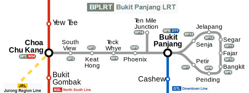
Pending on the Bukit Panjang LRT map
Pending station at a glance
| Station codes | BP8 |
|---|---|
| Lines | Bukit Panjang LRT |
| Interchange | No, single line station |
| Chinese name | 秉定 |
| Tamil name | பெண்டிங் |
| Next stations |
See Pending on the map. The interactive map opens with this station highlighted, so you can trace the route from where you are.
From Pending, the Bukit Panjang LRT runs in both directions along its loop route. The neighbouring stations are Petir on one side and Bangkit on the other, both of which are similarly residential stops without interchange connections to other MRT lines. To reach the wider rail network, passengers travel along the LRT to Bukit Panjang station, where a connection to the Downtown Line is available.
The area around Pending station is made up largely of HDB blocks, void decks, and the everyday amenities that accompany a mature Singapore housing estate, including neighbourhood shops and small food establishments within easy walking distance. There are no major landmarks or large commercial developments immediately beside the station, but residents find it a convenient starting point for daily errands within the Bukit Panjang neighbourhood.
Around Pending station
Pending LRT station sits within a predominantly residential neighbourhood in the Bukit Panjang area, surrounded by public housing estates and local amenities. The immediate vicinity is well served by food options, including Bukit Panjang Hawker Centre and Market and Bangkit Market, reflecting the everyday character of the area. Hillion Mall lies roughly 15 minutes away on foot, offering a broader retail option for residents.
| Place | Type | Distance | Why go |
|---|---|---|---|
| Pasar @ Level 2 | Market / hawker centre | About 200 m (~3 min walk) | Visit for a variety of market produce and cooked food stalls. |
| Bukit Panjang Hawker Centre and Market | Food centre | About 210 m (~3 min walk) | A popular local spot for hawker meals and fresh market shopping. |
| Fu Yuan Can Shi | Food centre | About 240 m (~4 min walk) | Head here for a selection of canteen-style cooked food options. |
| Kim San Leng Coffee Shop | Food centre | About 240 m (~4 min walk) | A traditional coffee shop serving local drinks and simple meals. |
| Masjid Al-Iman | Place of worship | About 270 m (~4 min walk) | A neighbourhood mosque for prayer and religious observance. |
| Bangkit Market | Market / hawker centre | About 290 m (~5 min walk) | Browse fresh produce and cooked food at this local market. |
| Pocket Greens Urban Farm & Barn | Attraction | About 800 m (~13 min walk) | Explore an urban farm with a barn-style space for a nature-based experience. |
| Hillion Mall | Shopping mall | About 920 m (~15 min walk) | Shop for a range of retail, dining and daily essentials at this mall. |
Places and straight-line distances from OpenStreetMap data (© OpenStreetMap contributors). Actual walking routes may be longer.
How to get to Pending by LRT
Worked out from the network map. Stop counts are station to station and do not include walking or waiting time.
| From Changi Airport | Take the East West Line from Changi Airport to Bugis (10 stops), then change to the Downtown Line from Bugis to Bukit Panjang (12 stops), then change to the Bukit Panjang LRT from Bukit Panjang to Pending (2 stops). About 24 stops with 2 changes. |
|---|---|
| From Orchard | Take the North South Line from Orchard to Newton (1 stop), then change to the Downtown Line from Newton to Bukit Panjang (9 stops), then change to the Bukit Panjang LRT from Bukit Panjang to Pending (2 stops). About 12 stops with 2 changes. |
| From City Hall | Take the North South Line from City Hall to Newton (4 stops), then change to the Downtown Line from Newton to Bukit Panjang (9 stops), then change to the Bukit Panjang LRT from Bukit Panjang to Pending (2 stops). About 15 stops with 2 changes. |
| From Jurong East | Take the North South Line from Jurong East to Choa Chu Kang (3 stops), then change to the Bukit Panjang LRT from Choa Chu Kang to Pending (7 stops). About 10 stops with 1 change. |
| From Woodlands | Take the North South Line from Woodlands to Choa Chu Kang (4 stops), then change to the Bukit Panjang LRT from Choa Chu Kang to Pending (7 stops). About 11 stops with 1 change. |
| From HarbourFront | Take the North East Line from HarbourFront to Little India (4 stops), then change to the Downtown Line from Little India to Bukit Panjang (10 stops), then change to the Bukit Panjang LRT from Bukit Panjang to Pending (2 stops). About 16 stops with 2 changes. |
Tips for using Pending station
- Several food centres are within a short walk of the station, making the area convenient for a quick meal without needing to travel further.
- Hillion Mall and Pocket Greens Urban Farm and Barn are considerably further away on foot, so consider whether you prefer to walk or take an alternative mode of transport.
- The Bukit Panjang LRT connects to the Downtown Line at Bukit Panjang station, which allows onward travel to more distant parts of Singapore with greater ease.
- During peak hours the LRT can be busy, so allow a little extra time when planning your journey to or from Pending station.
All stations on the Bukit Panjang LRT
In order along the line, with Pending marked. Stations with their own guide are linked.
| Code | Station | Interchange |
|---|---|---|
| BP1 | Choa Chu Kang | NS / BP |
| BP2 | South View | – |
| BP3 | Keat Hong | – |
| BP4 | Teck Whye | – |
| BP5 | Phoenix | – |
| BP6 | Bukit Panjang | DT / BP |
| BP7 | Petir | – |
| BP8 | Pending (you are here) | – |
| BP9 | Bangkit | – |
| BP10 | Fajar | – |
| BP11 | Segar | – |
| BP12 | Jelapang | – |
| BP13 | Senja | – |
Read the full Bukit Panjang LRT guide.
Pending station: common questions
Which line is Pending LRT station on?
Pending is on the Bukit Panjang LRT. Its station code is BP8.
Is Pending an interchange station?
No. Pending is served by the Bukit Panjang LRT only. The nearest interchange is shown in the next stations row above.
What is near Pending LRT station?
The station is surrounded by several food centres and markets, including Bukit Panjang Hawker Centre and Market and Bangkit Market, as well as Masjid Al-Iman. Hillion Mall and Pocket Greens Urban Farm and Barn are also reachable, though they are further away.
Which food centre or hawker centre is closest to Pending station?
Pasar @ Level 2 is approximately 200 metres away, making it the closest food and market option, with Bukit Panjang Hawker Centre and Market just slightly further at around 210 metres.
How far is Hillion Mall from Pending station?
Hillion Mall is approximately 920 metres from Pending station in a straight line, which is roughly a 15-minute walk.
How do I get to Pending from Changi Airport by LRT?
Take the East West Line from Changi Airport to Bugis (10 stops), then change to the Downtown Line from Bugis to Bukit Panjang (12 stops), then change to the Bukit Panjang LRT from Bukit Panjang to Pending (2 stops). About 24 stops with 2 changes.
Sources: station codes, line colours and interchanges from the LTA rail system map; operating hours from SMRT and SBS Transit. Last reviewed September 2026.
News and guides mentioning Pending
- Singapore MRT Network: Lines, Fares & How It All Works 29 Sep 2026
- Most Instagram-Worthy MRT Stations in Singapore 28 Sep 2026
- Playing Loud Music on the Bus? It’ll Cost You Hundreds 24 Sep 2026
- Upper Changi Homes Near MRT: URA Reviews Density Limits 23 Sep 2026
Plan the rest of the trip
Every station on the Bukit Panjang LRT is listed on its line guide, with the full route and interchanges. For times, see the first and last train guide, and for the whole network in one view use the interactive Singapore MRT map or the PDF map.