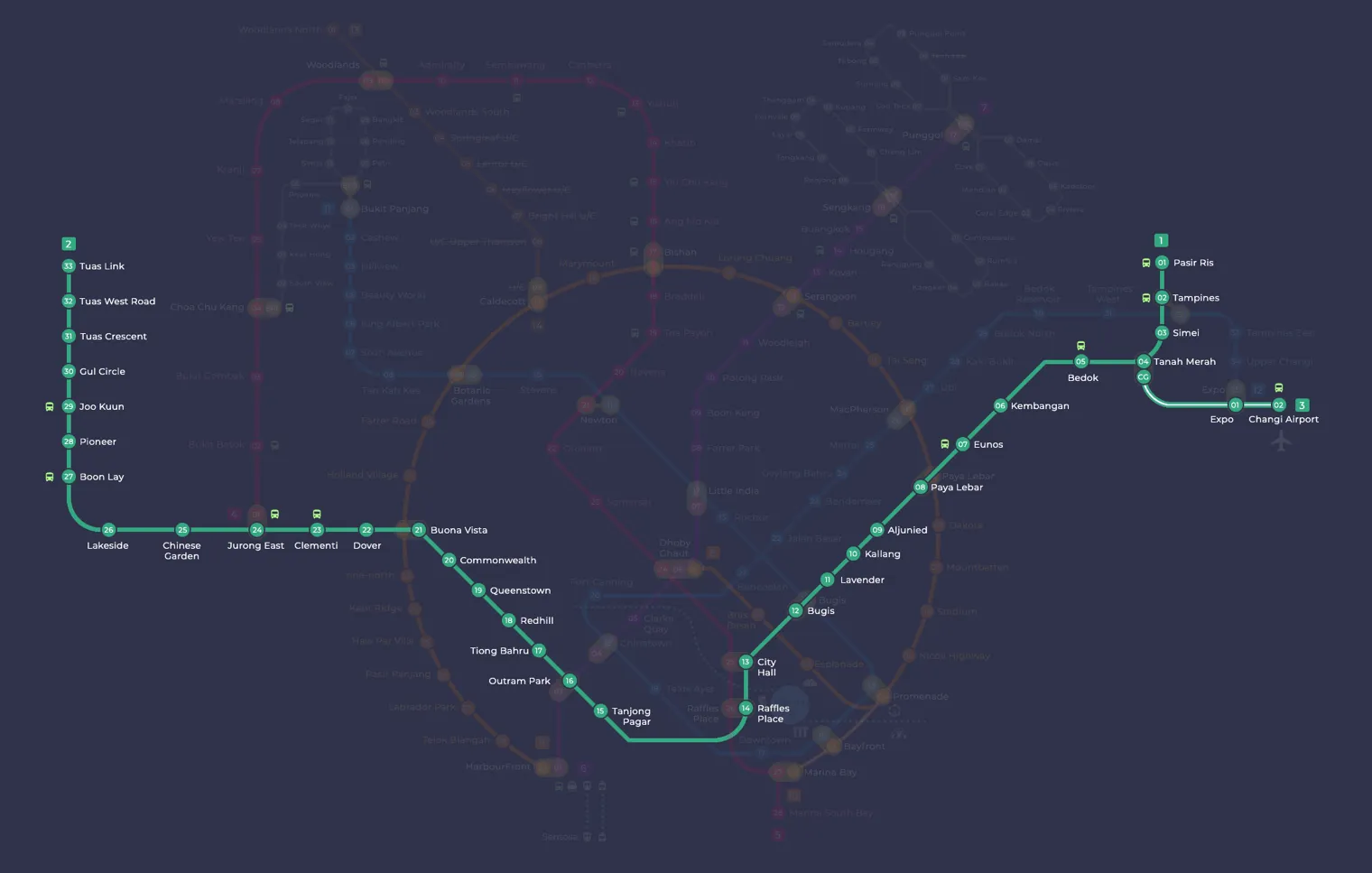
East West Line (Green Line MRT) guide
The East West Line is the green line MRT route that crosses Singapore from east to west. It is marked in green on the rail map, and its stations carry the code prefix EW. The main line runs from Pasir Ris (EW1) in the east to Tuas Link (EW33) in the far west. A short branch with the prefix CG leaves the main line at Tanah Merah and serves Expo (CG1) and Changi Airport (CG2). At 57.2 kilometres, it is the longest line on the MRT network.
The line links the eastern housing towns of Pasir Ris, Tampines and Bedok with the city centre, then continues through the older western estates to Jurong and the industrial area at Tuas. SMRT operates it. There are 35 stations open: 33 on the main line and 2 on the Changi Airport branch. Eight are underground: every station from Lavender to Tiong Bahru, plus Changi Airport. The rest are above ground.
Green Line MRT: route and where it goes
The line starts at Pasir Ris in the north east and heads south through Tampines, where it meets the Downtown Line, then on to Simei and Tanah Merah. Tanah Merah is where the Changi Airport branch begins. That branch runs to Expo, which also has a Downtown Line interchange, and ends at Changi Airport, an underground station between Terminal 2 and Terminal 3 with a terminal at each end. West of Tanah Merah, the main line passes through Bedok, Kembangan and Eunos to Paya Lebar, where you can change to the Circle Line, and then through Aljunied and Kallang.
From Lavender the green line MRT goes underground into the city. Bugis, City Hall, Raffles Place and Tanjong Pagar serve the central area. City Hall and Raffles Place connect with the North South Line, and Bugis connects with the Downtown Line. Outram Park is one of the busiest changing points on the network, with links to both the North East Line and the Thomson-East Coast Line. The tunnel section ends after Tiong Bahru.
Back above ground, the line passes Redhill, Queenstown and Commonwealth to Buona Vista, which has a second Circle Line interchange. Dover serves Singapore Polytechnic and the Dover housing estate, and Clementi follows. Jurong East is the western meeting point with the North South Line. After Chinese Garden, Lakeside and Boon Lay, which serve the Jurong West area, the line reaches Pioneer and Joo Koon on the edge of the Jurong Industrial Estate. The final four stations, Gul Circle, Tuas Crescent, Tuas West Road and Tuas Link, serve the Tuas industrial area.
Interchange stations
- Tampines (EW2): change to the Downtown Line (DT32).
- Paya Lebar (EW8): change to the Circle Line (CC9).
- Bugis (EW12): change to the Downtown Line (DT14).
- City Hall (EW13): change to the North South Line (NS25).
- Raffles Place (EW14): change to the North South Line (NS26).
- Outram Park (EW16): change to the Thomson-East Coast Line (TE17) and the North East Line (NE3).
- Buona Vista (EW21): change to the Circle Line (CC22).
- Jurong East (EW24): change to the North South Line (NS1).
- Expo (CG1): change to the Downtown Line (DT35).
History
The East West Line began life as part of the North South Line. Its first stretch, from City Hall to Outram Park, opened on 12 December 1987 as part of the first phase of the MRT. Trains reached Clementi on 12 March 1988 and Lakeside on 5 November 1988. The line became a separate service on 4 November 1989, when the eastern section to Tanah Merah opened, making it Singapore’s second MRT line. Pasir Ris followed ahead of schedule on 16 December 1989. The opening of Boon Lay on 6 July 1990 completed the original MRT system. Even after the split, both lines kept the same signalling equipment and trains.
Later additions filled gaps and pushed the line further out. Expo opened on 10 January 2001 and Changi Airport on 8 February 2002. Dover opened between Buona Vista and Clementi on 18 October 2001 and was the first infill station on the network. Pioneer and Joo Koon opened on 28 February 2009, and the Tuas West extension to Tuas Link started service on 18 June 2017. Half-height platform screen doors were added at the above-ground stations, and this work on the line finished on 31 August 2011. Major renewal work followed: timber sleepers were replaced with concrete, and the third rail was replaced between September 2015 and August 2017. A new signalling system has run the whole line full-day since 27 May 2018 and allows trains to run closer together at peak times. A turnback beyond Pasir Ris was completed in May 2024 so that trains can reverse more quickly there.
What is changing
The biggest planned change affects the Changi Airport branch. Tanah Merah, Expo and Changi Airport are set to become part of the Thomson-East Coast Line in the mid-2030s, when Changi Airport Terminal 5 opens. Under this plan, the line will continue from the airport to a new station at Terminal 5 and then join the rest of the Thomson-East Coast Line at Sungei Bedok. Work to adapt the branch stations for this began in 2025.
A new island platform at Tanah Merah was planned for completion in 2025. It is meant to shorten waits for trains to Expo and Changi Airport, and the extended tracks will also connect the line to the East Coast Integrated Depot. Once finished, Tanah Merah will have three island platforms side by side, as Jurong East does. More public artworks are also planned for stations on this line and the North South Line.
A proposed extension from Gul Circle to Tuas South will not go ahead in the near future. Gul Circle has two unused platforms built for it, but the plan was put on hold and later judged unfeasible in the short term. A bus rapid transit network is planned for Tuas South instead.
Tips for riding the line
- For Changi Airport, take a green line MRT train to Tanah Merah and change to the branch train there. The branch has run as a shuttle between Tanah Merah and Changi Airport, so most trips from the city involve this change.
- If you are coming from the Downtown Line, you can join the airport branch at Expo and avoid travelling back through Tanah Merah.
- For trips to the north of the island, change to the North South Line at City Hall or Raffles Place in the centre, or at Jurong East in the west.
- Outram Park is the most useful single interchange on the line, with links to both the North East Line and the Thomson-East Coast Line.
- For the Circle Line, use Paya Lebar on the eastern side of the line or Buona Vista on the western side, depending on where your journey starts.