

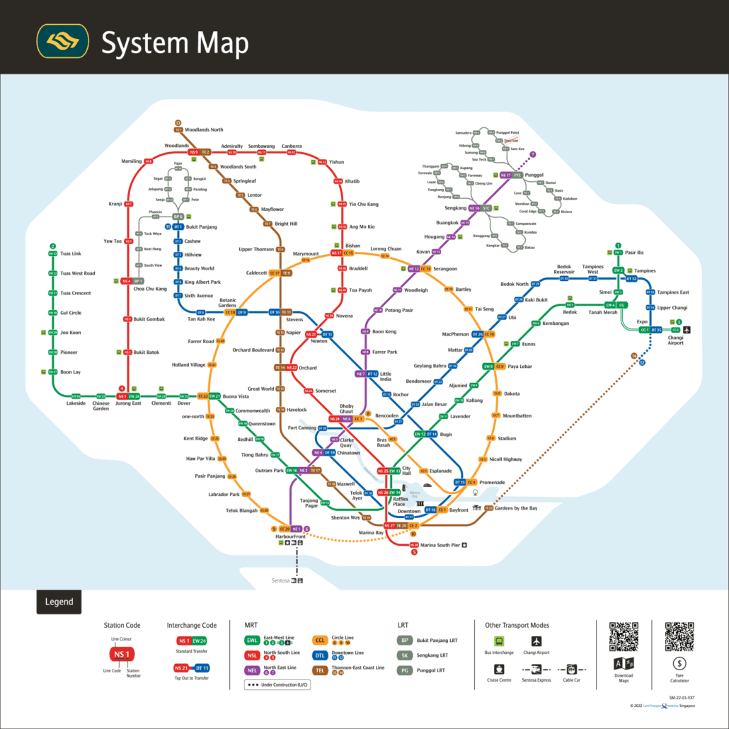
The MRT map in Bahasa Melayu above shows Singapore’s whole rail network with station names in Malay, the national language of Singapore and one of its four official languages. The line colours, station codes and layout match the English version exactly, so you can use it alongside any other map without confusion. For zooming and route planning, our interactive MRT map shows the network as it stands in October 2026. Open the interactive MRT map.
About the image: The map image above is LTA’s 2022 Malay edition (Peta Sistem), so it does not yet show the Thomson-East Coast Line beyond Gardens by the Bay, Punggol Coast, Hume or the completed Circle Line.
Who the Bahasa Melayu MRT map helps
Singapore has four official languages: English, Malay, Mandarin Chinese and Tamil. Every station name sign shows the name in all four, so the system already speaks Malay at the platform. A map in the same language makes planning easier before you set off.
This version is useful for:
- Malay speakers living in Singapore who would rather read a map in the language they use at home, or who are showing an older relative how to get somewhere.
- Visitors from Malaysia, Brunei and Indonesia, who will find the wording familiar and most station names easy to read and say.
- Students and teachers using the map as a real-world reading exercise, since the names connect directly to signs they will see on the network.
- Anyone helping someone else travel, because you can point to the same coloured line and the same code on two different language versions.
If someone in your group reads another language better, we also have the system map in Chinese, in Tamil and in Japanese. All of them follow the same colours and codes.
Getting around Singapore? Find any station on the interactive MRT map, or save the PDF map to use offline.
How station names work in Bahasa Melayu
Most station names are place names, so they are either identical or very close in Malay. A few are translated, though: on the map Botanic Gardens appears as Kebun Bunga and Gardens by the Bay as Taman di Pesisiran. In many cases, the English map is already using a Malay name.
Look at the eastern and northern ends of the network and you will see it straight away. Tanah Merah means “red earth”. Pasir Ris is the eastern terminus of the East West Line. Bukit Panjang, which means “long hill”, is the end of the Downtown Line and the start of the Bukit Panjang LRT. Kranji on the North South Line is another Malay place name that every language version keeps as it is.
The light rail lines carry plenty of Malay too. On the Bukit Panjang LRT you will find Senja, meaning dusk. The Punggol LRT East Loop includes Damai, meaning peace. Other names, such as Compassvale or HarbourFront, come from English, and the Malay map simply keeps them, written the way they appear on station signs.
The practical point is simple. If you know the English name of your stop, you can almost always find it on the Malay map without any guesswork, and the station code removes any remaining doubt.
Using the Bahasa Melayu map to get around
The quickest way to read any Singapore MRT map is by code and colour rather than by name. Each line has a two-letter prefix, and each station has a number. These never change between languages. Here is the network as it stands in October 2026:
| Line | Code | Open stations | From and to |
|---|---|---|---|
| North South Line | NS | 27 | Jurong East to Marina South Pier |
| East West Line | EW | 33 | Pasir Ris to Tuas Link |
| East West Line (Changi Airport branch) | CG | 2 | Expo to Changi Airport |
| North East Line | NE | 17 | HarbourFront to Punggol Coast |
| Circle Line | CC | 31 | Dhoby Ghaut to Prince Edward Road |
| Circle Line (Marina Bay extension) | CE | 2 | Bayfront to Marina Bay |
| Downtown Line | DT | 35 | Bukit Panjang to Expo |
| Thomson East Coast Line | TE | 27 | Woodlands North to Bayshore |
| Bukit Panjang LRT | BP | 13 | Choa Chu Kang to Senja |
| Sengkang LRT (East Loop) | SE | 5 | Compassvale to Ranggung |
| Sengkang LRT (West Loop) | SW | 8 | Cheng Lim to Renjong |
| Punggol LRT (East Loop) | PE | 7 | Cove to Damai |
| Punggol LRT (West Loop) | PW | 7 | Sam Kee to Soo Teck |
Interchanges are where two or more lines meet, and the map marks them with a combined symbol showing more than one code. Expo is a good example: the Changi Airport branch and the Downtown Line both end there, so it is where you change between them. When you plan a trip, find your start and end codes, then follow the colours to a station where they share a symbol. Our guide to line colours explains what each colour stands for.
A few practical tips:
- Quote the code when asking for directions. Staff and other passengers will recognise “NE18” whatever language you speak.
- Check recent changes. Circle Line Stage 6 opened in July 2026 with Keppel, Cantonment and Prince Edward Road, closing the Circle Line loop. Older printed maps will not show this.
- Do not head for unopened stations. Marina South, Mount Pleasant, Bedok South, Sungei Bedok and Xilin are not open yet. Our future MRT map shows what is coming.
- Plan the practical side too. Check the fares and fare calculator and the MRT operating hours before late journeys.
- Not sure where you are? The nearest station finder will point you to the closest stop.
Line names in Bahasa Melayu
The legend on the Malay map gives each line its Malay name: Laluan Timur-Barat (East West Line), Laluan Utara-Selatan (North South Line), Laluan Timur Laut (North East Line), Laluan Bulatan (Circle Line), Laluan Pusat Bandar (Downtown Line) and Laluan Thomson-Pantai Timur (Thomson-East Coast Line). The map title reads Peta Sistem, and the key is headed Petunjuk.
Frequently asked questions
Is the Bahasa Melayu map different from the English one?
Only in the language of the labels. Line colours, station codes and the layout are the same on every language version, so you can switch between them freely.
Are station signs in Singapore shown in Malay?
Yes. Station name signs show each name in English, Chinese, Malay and Tamil, so the names on this map match what you will see at the station.
Does this map include the newest stations?
Not all of them. The map image is LTA’s 2022 edition, drawn before Thomson-East Coast Line Stage 4 to Bayshore (opened 23 June 2024), Punggol Coast (NE18, opened 10 December 2024), Hume (DT4, opened 28 February 2025) and the Circle Line Stage 6 stations (July 2026). For the current network, use our interactive MRT map.
Can I print the map?
For a printable copy, download our MRT map PDF. It uses the same codes and colours, so it pairs easily with this Bahasa Melayu version.

For the official version, see the LTA rail network map.