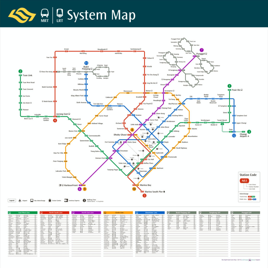
The MRT Walking Map (2017) is a nifty tool for locals and tourists alike to get around Singapore’s fairly large public transportation network. Unlike other flat maps that claim to assist you in discovering the city by foot, this map does help especially for Singapore, thanks to how bustling and interconnected the MRT (Mass Rapid Transit) network is across more of the island’s urban landscape.
MRT & Walkable Map (2017)
In 2017, The MRT Walking Map was introduced to aid commuters in identifying the fastest way on foot between the different MRT stations! Rather than simply hunting visually on a standard MRT map of the rail network, this Walking Map can show you at a glance which stations are near to each other walking-wise. Not making needless transfers so that one can travel faster and on foot, which is often the more aesthetic or direct route.
Key Features of the MRT Walking Map
-
Station Proximity Information:
Within the map itself, the detailed station distance (in meters and time) map In an area like the CBD, where stations are sometimes just down the street from each other—think City Hall versus Raffles Place, or Orchard and Somerset—this can be especially useful.
-
Scenic Walking Routes:
The MRT Walking Map highlights routes that pass by some of Singapore’s other iconic sights — it’s not all about speed and efficiency. Whether you are on foot from Bugis to Little India or Chinatown to Tanjong Pagar, the map encourages the discovery of Singapore’s diverse fabrics.
-
Accessibility and Convenience:
They were all about Accessibility and Convenience. Those who would rather walk than change 02 times in the metro or breach through a mobbed station are excited to hand again their EZ-Link Cards. It is the less stressful method to combine between lines and stations, reducing peak hour rush from traffic as well offers a better travelling experience.
- Innovative MRT Walking Map
For Tourists and Locals An MRT Walking Map to Optimize Your Commuter Experience This is especially so when shortening the time needed to travel from one attraction spot, which in turn cuts down on planning multiple MRT transfers if you are looking for a place of interest that can be visited within a day.
How to Use the MRT Walking Map
You do not need extensive instructions to use the MRT Walking Map. You can just zoom in on your starting station and destination, then see if there is a route you may walk between the two on the map. The map will even inform you how long it takes to walk if a walking path is available, and it enables pursuing the course, overtaking the next train, or altering lines.
This means it finds the shortest route when travelling to another MRT Station, such as transferring from Chinatown MRT Station to Clarke Quay MRT Station without needing to go via Outram Park.
Conclusion
With that in mind, here is the MRT Walking Map 2017, which covers most of Singapore’s major stations. This offers commuters clear and concise details on walking routes between stations, in a way making their rides smoother and more delightful. The MRT Walking Working or visiting the daily grind has never been easier.
Are You Ready To Experience A Paris Way Of Life And Find Elegance With Minimal While You On Feet Travel Along Singapore’s Dynamic Cityscapes?

