
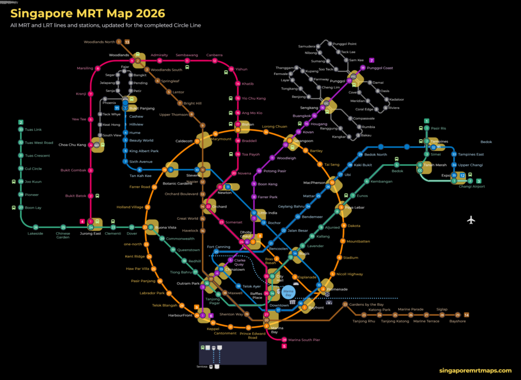
シンガポールMRT路線図の2026年版を、現地在住の編集者が日本語でわかりやすく解説します。MRTは6路線、LRT(軽量高架鉄道)は3路線あり、チャンギ空港やオーチャード、マリーナベイ、セントーサ島の玄関口ハーバーフロントなど、観光の主要スポットへは電車で行けます。上の路線図は英語表記ですが、このページで路線の色や駅コード、駅名の読み方を確認しておけば迷うことはありません。拡大して見られるインタラクティブ路線図(英語)と、オフラインでも使える無料のPDF版路線図もご用意しています。 シンガポールMRT路線図の見方 シンガポールのMRTとLRTは、路線ごとに色が決まっています。南北線は赤、東西線は緑、北東線は紫、サークル線は橙、ダウンタウン線は青、トムソン・イーストコースト線は茶、LRTは灰色です。まずは乗りたい路線の色を路線図で探すのが一番の近道です。 各駅には「NS24」「EW13」のような駅コードが付いています。アルファベットが路線、数字がその路線上の駅の順番を表します。数字の大小を見れば、どちら方面に進めばよいかもすぐにわかります。 乗換駅は複数のコードを持っています。たとえばドビー・ゴート(Dhoby Ghaut)は「NS24/NE6/CC1」で、南北線、北東線、サークル線の3路線が乗り入れていることがわかります。 路線図には、まだ開業していない将来の駅も表示されています。2026年10月現在、Marina South、Mount Pleasant、Bedok South、Sungei Bedok、Xilinの各駅は未開業ですので、ご注意ください。 駅名の看板は英語・中国語・マレー語・タミル語の4言語表記です。日本語表記はありませんが、英語の駅名と駅コードを照らし合わせれば問題なく移動できます。 MRT・LRT全路線一覧(2026年) 路線 色 コード 区間 駅数 南北線(North South Line) 赤 NS Jurong East〜Marina South Pier 27 東西線(East West Line) 緑 EW / CG Pasir Ris〜Tuas Link、チャンギ空港支線(Expo〜Changi Airport) 35(本線33、支線2) 北東線(North East Line) 紫 NE HarbourFront〜Punggol Coast 17 サークル線(Circle Line) 橙 CC / CE 環状線(2026年7月に全線開通)、マリーナベイ支線(Bayfront〜Marina […]
Category Archives: Maps
Blog
Lakeside MRT Delay: How to Beat the Morning Rush Queues
A brief delay during the morning rush on 21 October 2026 left long queues at [...]
Continue readingOct
Blog
Future MRT Map Singapore: Every New Line and Extension to 2040
The future MRT map of Singapore adds two completely new lines, the Jurong Region Line [...]
Continue reading
Blog
Labrador Park MRT: SMRT Staff Help Injured Cyclist
SMRT staff helped a cyclist with head and face injuries outside Labrador Park MRT and [...]
Continue readingOct

Blog
Chain collision of 3 buses in Yishun injures 5 riders
Five passengers were injured when a Tower Transit bus rear-ended an SBS Transit bus at [...]
Continue readingOct

Blog
Woodlands MRT Smokers Leave Butts: What Riders Can Do
The Independent Singapore reported on 13 October 2026 that smokers gathering near Woodlands MRT leave [...]
Continue readingOct
Jan
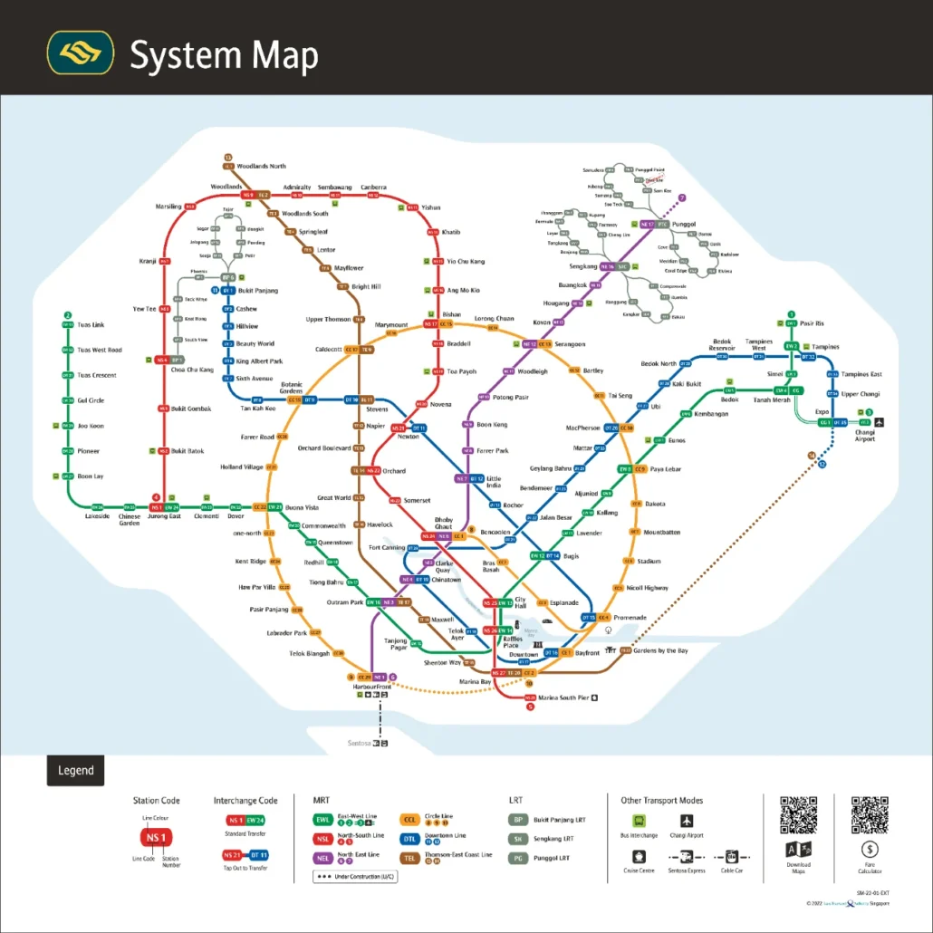
Singapore MRT Map PDF 2026 Download Updated for 2026: the PDF is the official Land Transport Authority system map, version dated 21 July 2026. It includes the completed Circle Line loop (Keppel, Cantonment and Prince Edward Road), Hume on the Downtown Line, Punggol Coast on the North East Line, and the Thomson-East Coast Line through […]
Aug
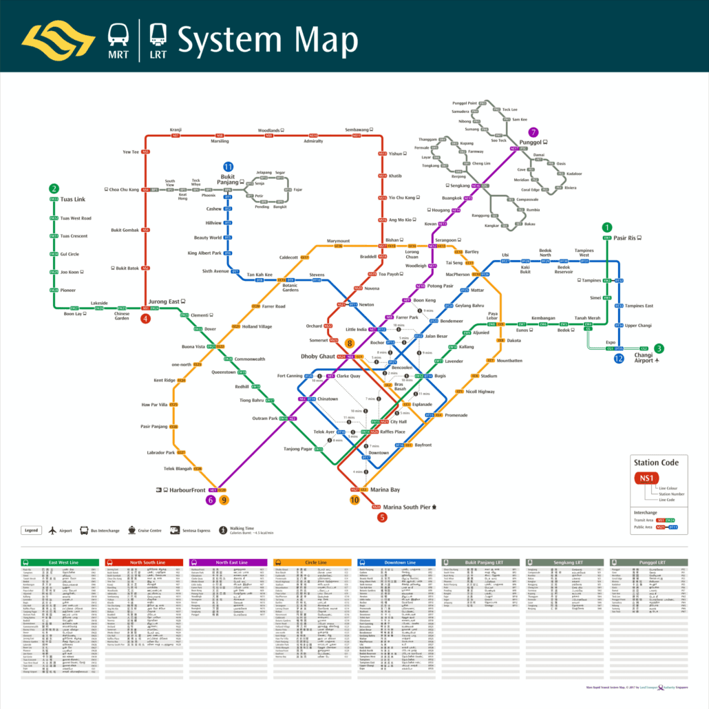
This MRT walking map is the 2017 Land Transport Authority system map with walking links added, showing the MRT and LRT network as it stood in late 2017 along with dotted lines between city centre stations that sit close enough to walk between. It records a network just after the East West Line reached Tuas […]

Aug
The MRT map 2017 shown above is Singapore’s rail system map as it stood in 2017, a year of real change for the network. It captures the system after the opening of the Tuas West Extension and around the arrival of the final stage of the Downtown Line, but well before the Thomson East Coast […]

Aug
This MRT map 2016 shows Singapore’s rail network as it stood in 2016, after Downtown Line Stage 2 opened and before the major 2017 extensions. It is useful for checking old journeys, matching photos or documents to a date, and seeing how much the system has grown. For planning a trip today, use our interactive […]
Aug
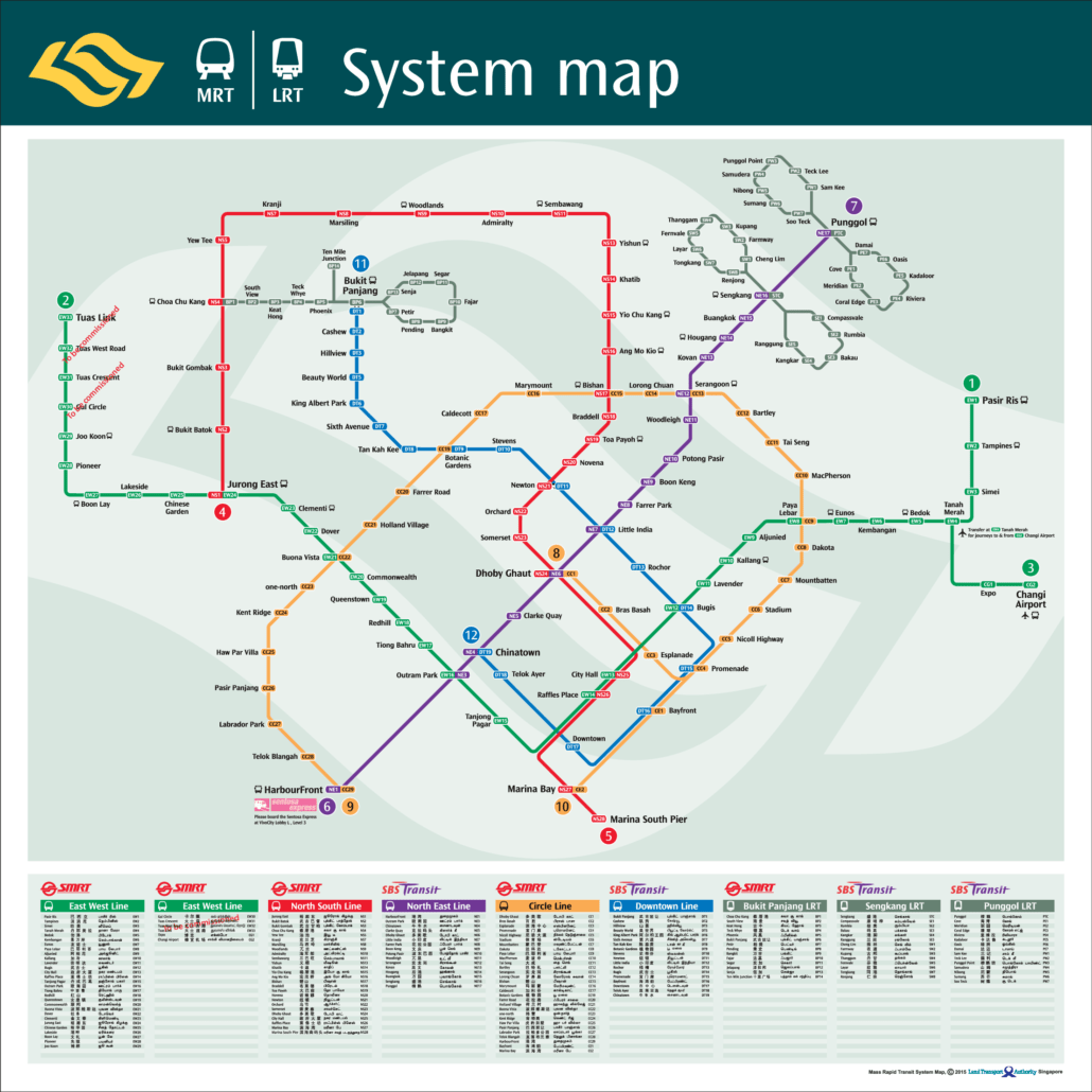
This MRT map 2015 shows Singapore’s rail network as it stood in 2015, before the Downtown Line was complete and before the Thomson East Coast Line existed. It is worth keeping as a record. The network was in the middle of a long expansion, and this map captures it partway. If you need to plan […]
Aug
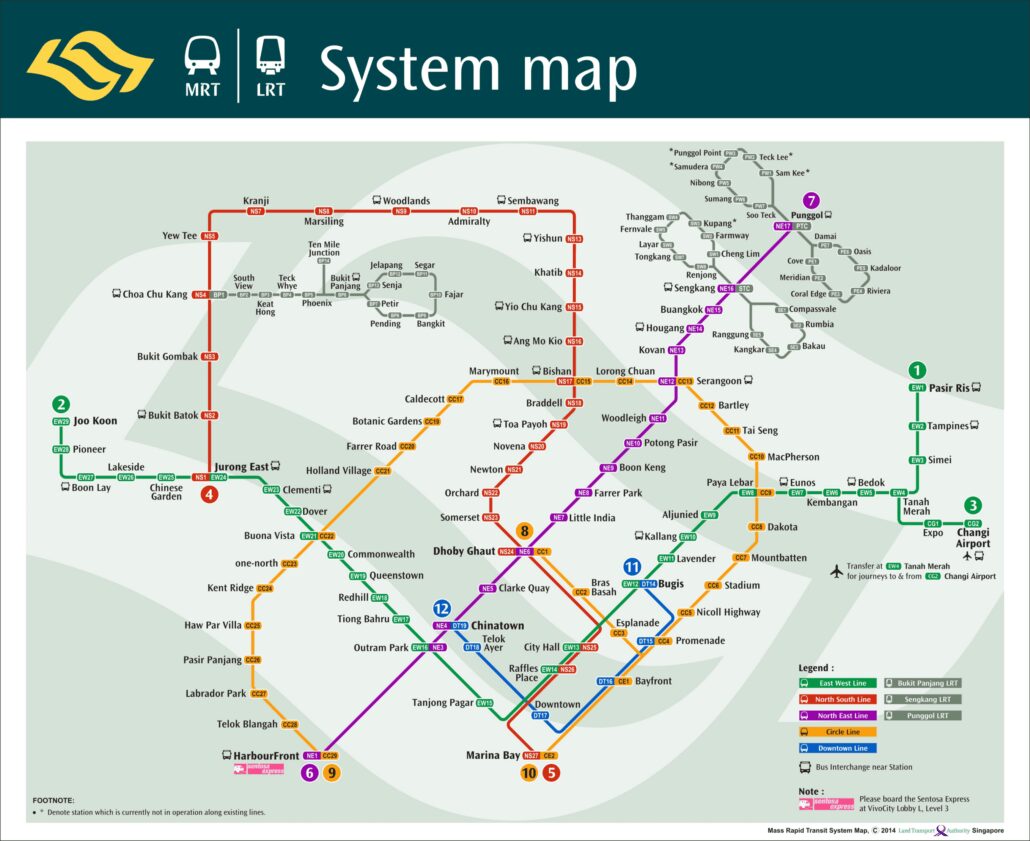
The MRT map 2014 is the official system map of Singapore’s rail network as it stood in 2014, shown in the image above. It captures a network in transition: the Circle Line was running, the first stage of the Downtown Line had only just opened, and the Thomson East Coast Line was still years away. […]
Aug
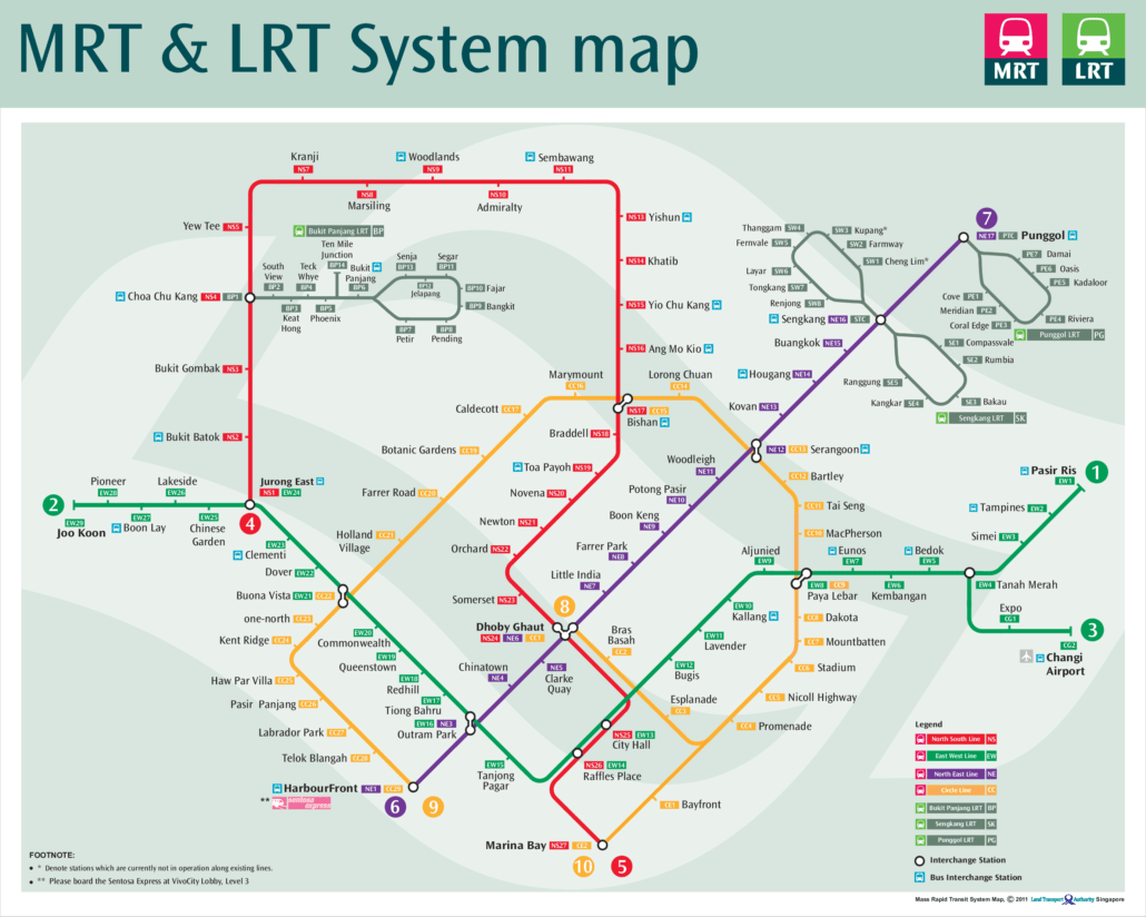
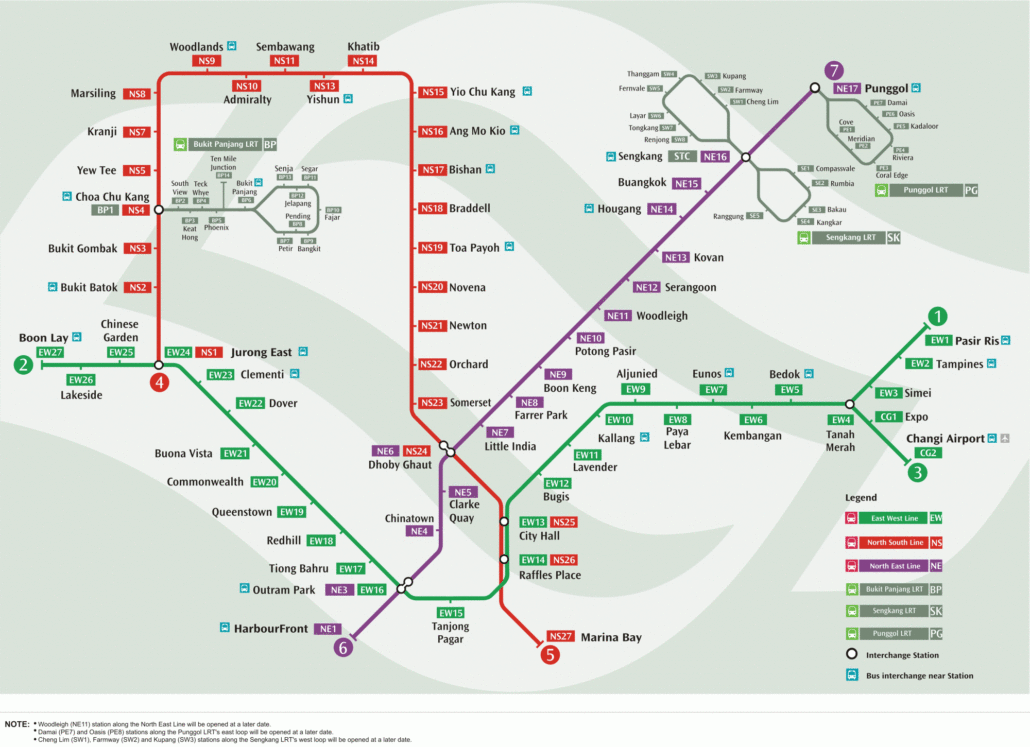
This MRT map 2011 shows Singapore’s rail network as it stood in 2011, before the Downtown Line or the Thomson East Coast Line existed. It is a useful snapshot of a system in transition. The North East Line had just gained a new station, and the Circle Line was still being opened in stages. If […]
Aug
This MRT map 2006 shows Singapore’s rail network as it stood in 2006, a few years after the North East Line opened and a few years before the Circle Line arrived. It is a useful record of a smaller, simpler system: two long MRT lines built by the original operator, one newer automated line, and […]
Aug
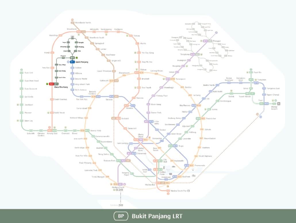
This Bukit Panjang LRT map shows the light rail line that serves Bukit Panjang and Choa Chu Kang in the west of Singapore, drawn in grey and coded BP on network signage. The line runs from Choa Chu Kang (BP1) to Senja (BP13), and all 13 of its stations are open. It works as a […]