
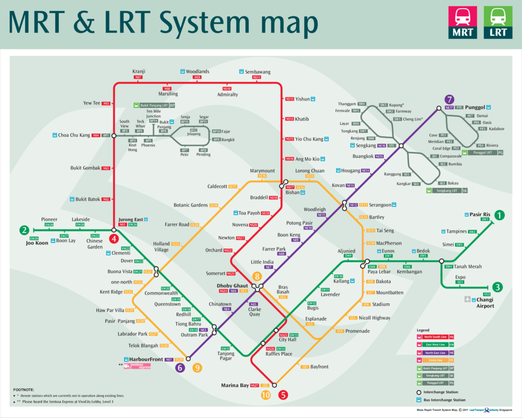
This MRT map 2011 shows Singapore’s rail network as it stood in 2011, before the Downtown Line or the Thomson East Coast Line existed. It is a useful snapshot of a system in transition. The North East Line had just gained a new station, and the Circle Line was still being opened in stages. If you have an old printed map in a drawer, or you are simply curious about how much has changed, this is the version many commuters carried that year.
What the MRT map 2011 shows
The 2011 map is built around four MRT lines and the light rail feeders that connected housing estates to them. Compared with today’s network it looks simple, but most of the familiar core was already there.
- North South Line: the oldest part of the system. Its first section opened on 7 November 1987. The Woodlands extension, completed on 10 February 1996, joined Yishun and Choa Chu Kang and absorbed the old Branch Line, giving the line the loop through the north that it still has.
- East West Line: running across the island, with the Boon Lay Extension to Pioneer and Joo Koon in place since 28 February 2009. Joo Koon was therefore the western end in 2011. The Changi Airport branch was also shown, with Expo (opened 10 January 2001) and Changi Airport (opened 8 February 2002). Dover, the network’s first infill station, had been open since 18 October 2001.
- North East Line: opened on 20 June 2003 as one of the first fully automated heavy rail lines in the world. By 2011 it included Buangkok, which opened on 15 January 2006 after public lobbying, and Woodleigh, which opened on 20 June 2011.
- Circle Line: the newest line on the map, and the part that changed during the year. Stage 3 opened on 28 May 2009, and Stages 1 and 2 followed on 17 April 2010. Stages 4 and 5 opened on 8 October 2011. Depending on whether a copy was printed before or after that date, the Circle Line appears as a partial arc or as a much longer line. Either way, the stretch past HarbourFront needed to close the loop was still years away.
- Light rail: the Bukit Panjang LRT, running since 6 November 1999, along with the Sengkang and Punggol LRT loops feeding the North East Line.
What you will not find is any sign of the Downtown Line or the Thomson East Coast Line. Large parts of Bukit Timah, the Thomson corridor and the east coast had no rail service at all.
Getting around Singapore? Find any station on the interactive MRT map, or save the PDF map to use offline.
What opened around this time
The years either side of 2011 were busy. Here are the dated openings closest to this map:
| Date | Opening |
|---|---|
| 28 February 2009 | East West Line Boon Lay Extension (Pioneer, Joo Koon) |
| 28 May 2009 | Circle Line Stage 3 |
| 17 April 2010 | Circle Line Stages 1 and 2 |
| 20 June 2011 | Woodleigh station, North East Line |
| 8 October 2011 | Circle Line Stages 4 and 5 |
| 14 January 2012 | Circle Line Extension |
| 22 December 2013 | Downtown Line Stage 1 |
So within a few months of this map, the Circle Line Extension had been added. Within two years, the Downtown Line had begun carrying passengers, and the map started to look quite different.
How the network has changed since
As of October 2026, the network has grown from four MRT lines to six, and several lines on the 2011 map have been extended. Here is how each line compares:
| Line | In 2011 | October 2026 |
|---|---|---|
| North South Line | Open | 27 stations, Jurong East to Marina South Pier |
| East West Line | Western end at Joo Koon | 33 stations, Pasir Ris to Tuas Link, plus 2 on the Changi Airport branch |
| North East Line | Northern end at Punggol | 17 stations, HarbourFront to Punggol Coast |
| Circle Line | Opening in stages | 31 stations, Dhoby Ghaut to Prince Edward Road, plus 2 on the Marina Bay extension |
| Downtown Line | Not open | 35 stations, Bukit Panjang to Expo |
| Thomson East Coast Line | Not open | 27 stations, Woodlands North to Bayshore |
The biggest additions are the two new lines. The Downtown Line opened in three stages between 2013 and 21 October 2017, and gained the infill station Hume on 28 February 2025. The Thomson East Coast Line opened in stages from 31 January 2020, reaching Bayshore on 23 June 2024.
The older lines have grown too. The Tuas West Extension added Gul Circle, Tuas Crescent, Tuas West Road and Tuas Link on 18 June 2017. Canberra opened as an infill station on 2 November 2019. Punggol Coast joined the North East Line on 10 December 2024. Most significantly, Circle Line Stage 6 opened on 12 July 2026 with Keppel, Cantonment and Prince Edward Road, finally closing the loop that was only half drawn on the 2011 map.
A few stations are still to come: Marina South, Mount Pleasant, Bedok South, Sungei Bedok and Xilin. For planned lines and extensions, see our future MRT map.
If you are planning a journey today, use our interactive MRT map rather than an old printout, as routes and interchanges have changed a great deal.
Frequently asked questions
Was the Downtown Line on the MRT map 2011?
No. The Downtown Line’s first stage opened on 22 December 2013, so it does not appear on any 2011 map.
Why do some 2011 maps show more of the Circle Line than others?
Circle Line Stages 4 and 5 opened on 8 October 2011. Maps printed earlier in the year show a shorter line, while later versions include the new stretch. The Circle Line Extension followed on 14 January 2012.
Which stations opened in 2011?
Woodleigh on the North East Line opened on 20 June 2011. The Circle Line Stages 4 and 5 stations opened on 8 October 2011.
Where can I get the current map?
You can download our up to date MRT map PDF for printing or offline use.
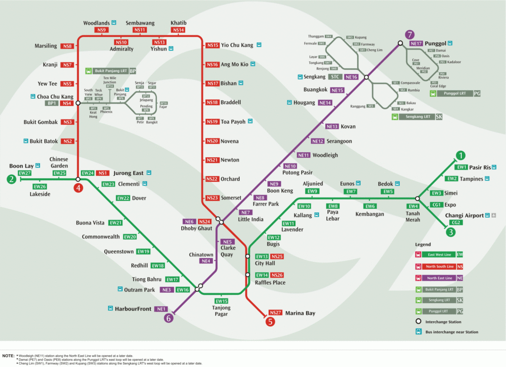
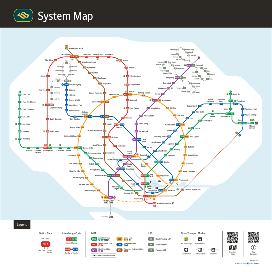
For the official version, see the LTA rail network map.