

The East West Line map traces Singapore’s green line, running from Pasir Ris (EW1) in the east to Tuas Link (EW33) in the far west. All 33 stations on the main line are open, numbered in order from EW1 to EW33, and a short two-station branch (coded CG) leaves the line for Expo and Changi […]
Author Archives: MRT Map of Singapore Editorial Team
Blog
Singapore Rail Academy Expands: What It Means for Riders
The Singapore Rail Academy will bring technicians and operations staff into its courses and introduce [...]
Continue reading
26
Oct
Oct
Blog
Lakeside MRT Delay: How to Beat the Morning Rush Queues
A brief delay during the morning rush on 21 October 2026 left long queues at [...]
Continue reading
22
Oct
Oct
Blog
Future MRT Map Singapore: Every New Line and Extension to 2040
The future MRT map of Singapore adds two completely new lines, the Jurong Region Line [...]
Continue reading
Blog
Labrador Park MRT: SMRT Staff Help Injured Cyclist
SMRT staff helped a cyclist with head and face injuries outside Labrador Park MRT and [...]
Continue reading
19
Oct
Oct

Blog
Chain collision of 3 buses in Yishun injures 5 riders
Five passengers were injured when a Tower Transit bus rear-ended an SBS Transit bus at [...]
Continue reading
16
Oct
Oct
11
Aug
Aug
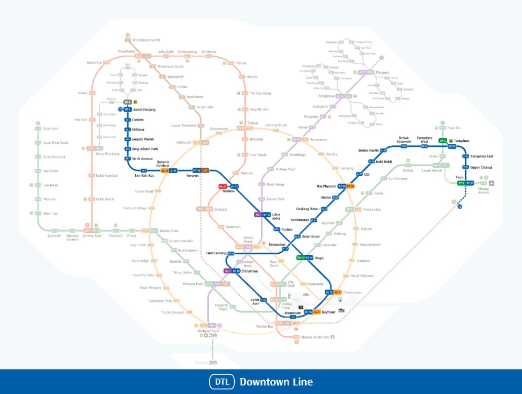
This Downtown Line map shows the whole of Singapore’s blue line, coded DT, from Bukit Panjang (DT1) in the north-west to Expo (DT35) in the east. All 35 stations are open, and the line passes through the heart of the city on the way, linking to every other MRT line along its route. Use the […]

11
Aug
Aug
The Circle Line map above traces Singapore’s orbital MRT route, drawn in orange with station codes beginning CC. The main line runs from Dhoby Ghaut (CC1) to Prince Edward Road (CC32), with 31 stations open, and a short Marina Bay extension coded CE adds two more at Bayfront and Marina Bay. Since Stage 6 opened […]

11
Aug
Aug
An MRT map in Tamil shows Singapore’s rail network with every station name written in Tamil script, so Tamil readers can plan a journey without switching to English. The map above uses the same lines, colours and station codes as the English version. Only the names change, which means you can carry it onto the […]

11
Aug
Aug
The MRT map in Bahasa Melayu above shows Singapore’s whole rail network with station names in Malay, the national language of Singapore and one of its four official languages. The line colours, station codes and layout match the English version exactly, so you can use it alongside any other map without confusion. For zooming and […]

11
Aug
Aug
An MRT map in Chinese shows the same Singapore rail network you see on the English version, with every station labelled using its official Chinese name. The large map above uses those names throughout, while the line colours, station codes and route shapes stay exactly as they are on the standard system map. That means […]
11
Aug
Aug
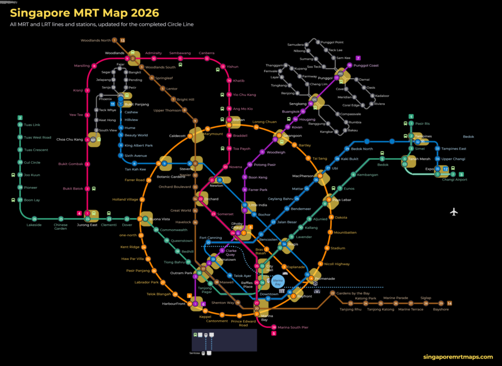
This SG MRT map is our own full-size image of Singapore’s rail network as it stands in October 2026. It shows every MRT and LRT line and station now in service, with stations that have not yet opened marked as future stops. We have updated it for the completed Circle Line, which became a full […]
11
Aug
Aug
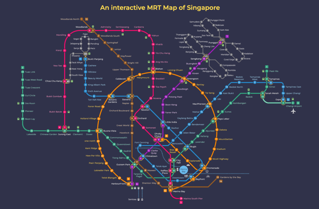
This MRT map dark mode version shows the full Singapore network on a dark background. The Singapore MRT covers the whole island, linking neighbourhoods from Jurong in the west to Changi in the east, and Woodlands in the north to HarbourFront in the south. Whether you are heading to work, the airport, or somewhere new, […]
11
Aug
Aug
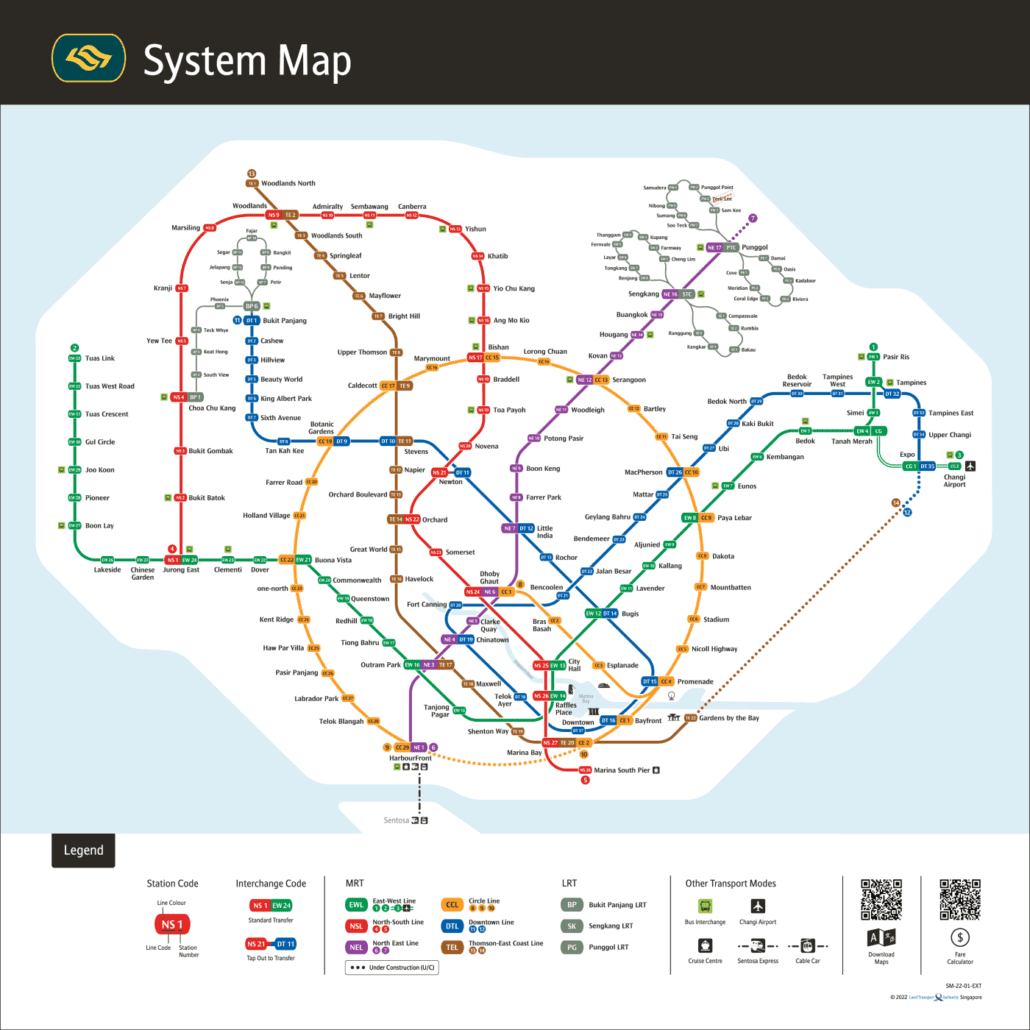
MRT MAP This is the official MRT map LTA issues for Singapore’s rail network: the System Map, edition SM-26-01-EN, published in 2026. LTA is the Land Transport Authority, the government body that plans the network, while the trains themselves are run by two operators, SMRT and SBS Transit. Because it comes straight from LTA, this […]