
Last updated . Facts checked against LTA announcements.
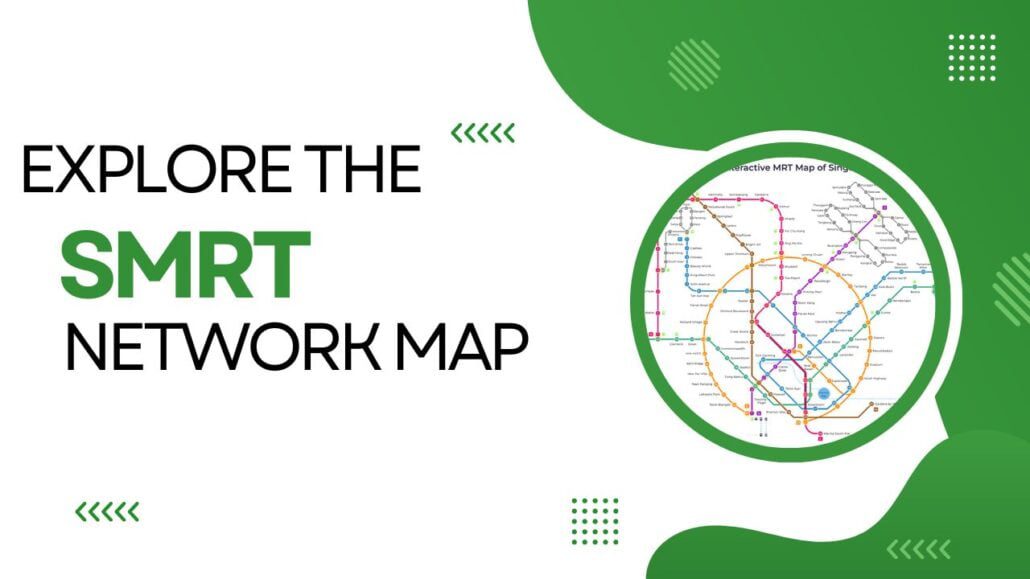
Want to travel around Singapore by train? The SMRT Network Map shows you every line, station and interchange so you can plan your journey before you leave home. Coverage is extensive, and most major attractions, neighbourhoods and transport hubs sit within easy walking distance of a station.
This section walks you through the SMRT Network Map and what it covers, so you know exactly what to expect on your commute or day out.
Key Takeaways:
- The SMRT Network Map gives you a clear picture of Singapore’s train lines, stations and connections.
- Each line is colour-coded, making it straightforward to trace your route at a glance.
- Interchange stations let you switch between lines without leaving the paid area.
- Knowing the map helps you pick the quickest path between any two points in the city.
Understanding the SMRT Network Map
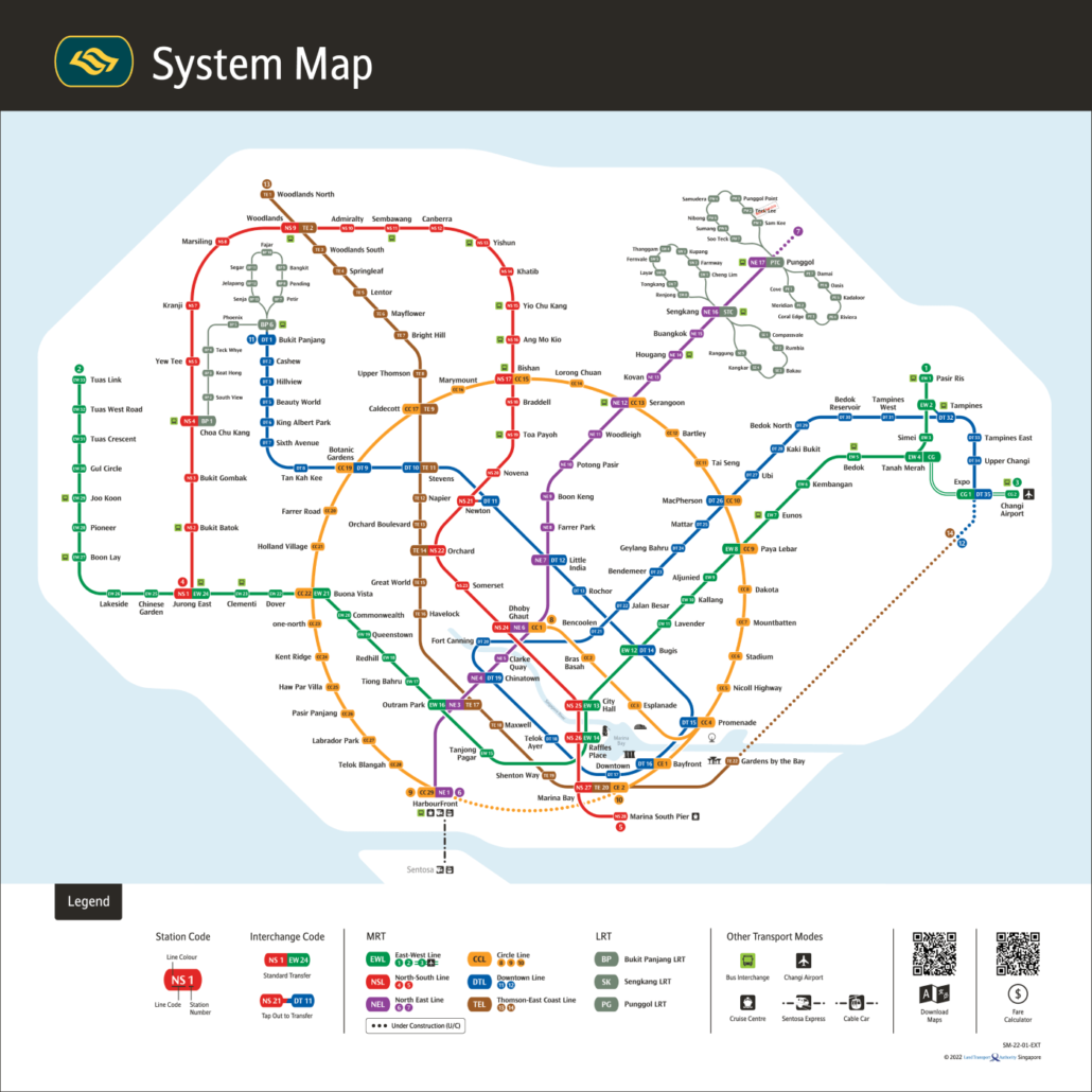
The SMRT Network Map shows every line, station and interchange on Singapore’s rail network, giving you what you need to plan a trip from one end of the island to the other. Getting familiar with it makes a real difference to how quickly you get around.
Each line is colour-coded: red for the North South Line, green for the East West Line, purple for the North East Line, orange for the Circle Line, blue for the Downtown Line and brown for the Thomson-East Coast Line. Lines cross at interchange stations, where you can switch between services without paying again. The map also helps you spot which stations are closest to where you want to go.
Note that not all lines are operated by SMRT. SMRT runs the North South, East West, Circle and Thomson-East Coast lines, as well as the Bukit Panjang LRT. SBS Transit operates the North East and Downtown lines, plus the Sengkang and Punggol LRT systems. For a passenger it makes little practical difference, but it is good to know when looking up service updates or lost property contacts.
Key Features of the SMRT Network Map
The SMRT network map shows you the train routes and stops you need to plan any journey across Singapore. Get familiar with the colour-coded lines, interchange stations and branch lines, and you will find it straightforward to get from A to B.
| Map Legend | Function |
|---|---|
| Train Line Colors | Allows you to recognize the train line easily |
| Stations | Shows all current rail station names and locations. |
| Interchange Stations | Platform to platform indicates the interchange between a particular train lines |
Use the SMRT network map to plan your route before you travel, and check it for updates on service delays or disruptions.
Getting around Singapore? Find any station on the interactive MRT map, or save the PDF map to use offline.
Exploring the SMRT Train Routes
Singapore’s train system covers most of the city and is one of the quickest ways to get around. Knowing the different lines and where they go makes it much easier to pick the right route for your trip.
| Line | Route |
|---|---|
| North-South Line | Between Jurong East in the west and Marina South Pier in the south, with key sights like Chinatown and Clarke Quay near attraction hub Orchard Road. |
| East-West Line | This connection line extends from Pasir Ris in the East and to Tuas Link in the West, with stops/exchanges at Changi Airport, City Hall, and Jurong East. |
| North-East Line | From HarbourFront in the south to Punggol in the north, with key stops like Little India and Serangoon. |
| Circle Line | From Bukit Panjang in the North to Expo in the East, with stations at places like Bugis and Chinatown. |
| Downtown Line | Starting from Bukit Panjang in the north, through Expo to the east and stops at destinations like Bugis & Chinatown. |
Several stations are interchanges where you can switch between lines, so it is worth identifying those on the map before you set off. Check the full list of MRT stations if you want a closer look at a particular stop.
A useful habit: aim for the route with the fewest line changes, as staying on one line from start to finish is usually quicker than switching trains in the city centre.
Benefits of Using the SMRT Network Map
The SMRT network map is a practical tool for getting around Singapore by train. Whether you are planning a new commute or just need a quick reference, it takes the guesswork out of your journey.
- Save time: Spot the quickest route between two stations at a glance, so you can plan transfers and avoid unnecessary backtracking.
- Easy to read: Each line is colour-coded and clearly labelled, making it straightforward to follow even if you are new to the network.
- Up to date: The map reflects the current network layout, including recently opened stations and lines.
- Accessibility: You can quickly check which station is closest to your destination and plan your exit accordingly.
Keep the map handy and you will spend less time puzzling over routes and more time actually getting where you need to go.
The SMRT Network Map Helps You to Plan Your Journey
The SMRT Network Map is a practical starting point for planning any trip. Pick your starting station, pick your destination, and the map lays out your route across all the MRT and LRT lines.
Each line has its own colour, so it is easy to tell the North South Line (red) from the East West Line (green), the Downtown Line (blue), and so on. That colour-coding makes the map quick to read even when you are in a hurry.
You can also use the map to get a rough sense of journey time by counting the stations and interchanges along your route. Knowing where you need to change trains in advance saves a lot of confusion on the platform.
Tips for Getting Around the SMRT System
A few simple habits make a real difference when riding the MRT, whether you are new to Singapore or just new to a particular line.
Travel Off-Peak Hours
If you want a more comfortable ride, try to avoid the morning and evening rush hours. On weekdays, trains are busiest roughly from 7:30 to 9:30 in the morning and again from around 5:00 to 8:00 in the evening. Weekends and public holidays are generally much quieter throughout the day.
Use the SMRT Journey Planner
The SMRT journey planner helps you compare routes and find the quickest or most convenient option between any two points. You can access it on the SMRT website or through a free mobile app.
Keep a Singapore MRT Map Handy
Grab a printed or digital copy of the Singapore MRT map before you head out. It shows station names, line routes and interchange points clearly, so you always know where you are and where you need to change.
Be Mindful of Platform and Train Allocations
Before boarding, check the electronic notice boards on the platform. They show which train is arriving and confirm the direction it is heading, so you can be sure you are on the right service.
Tap Out to Avoid Overcharging
Always tap your card or device when you exit the station, not just when you enter. Whether you are using an EZ-Link card, a SimplyGo card or a contactless bank card, failing to tap out may result in the maximum fare being deducted for that journey.
Exploring Beyond SMRT with Interchange Stations
The network covers most of Singapore, but you will often need to change lines to reach your destination. Interchange stations connect two or more lines in one place, so transferring between services is straightforward.
Key interchange stations you should know:
| Interchange Station | Lines |
|---|---|
| Dhoby Ghaut | North-South, North-East, Circle lines |
| Raffles Place | North-South, East-West lines |
| City Hall | North-South, East-West lines |
| HarbourFront | North-East, Circle lines |
These stations sit where multiple lines cross, making it easy to move between different parts of the network. Many also have shopping and food options if you want a bite between connections.
Factor these interchanges into your journey planning, and check the Singapore MRT network map for a full picture of all routes and connections.
Plan Your Next Trip with the SMRT Network Map
Keep the SMRT Network Map handy whenever you are getting around Singapore by train. Spend a few minutes looking at the routes and interchanges before you head out, and you will save yourself a lot of guesswork on the platform.
From Chinatown to Marina Bay and beyond, the map gives you a clear picture of how the lines connect. Use it to find the quickest route and travel with confidence.
For official updates on the rail network, check the Land Transport Authority (LTA) website.
Frequently asked questions
How do I pay for MRT fares in Singapore?
You can pay by tapping an EZ-Link card, a SimplyGo card, a contactless bank card or a mobile wallet at the fare gates. If you are visiting Singapore for a short trip, a Singapore Tourist Pass lets you make unlimited train and bus rides for a set number of days without tapping individual journeys.
What is the newest MRT station to open in Singapore?
The newest stations are Keppel, Cantonment and Prince Edward Road on the Circle Line, which opened on 12 July 2026 and completed the loop. Before that, Hume joined the Downtown Line on 28 February 2025.
What MRT lines are coming soon in Singapore?
The Thomson-East Coast Line Stage 5, adding Bedok South and Sungei Bedok, and the Downtown Line 3 Extension to Xilin and Sungei Bedok are both due in the second half of 2026. Further ahead, the Jurong Region Line Stage 1 is targeted around mid-2028, and the Cross Island Line Phase 1 is aimed at 2030.