
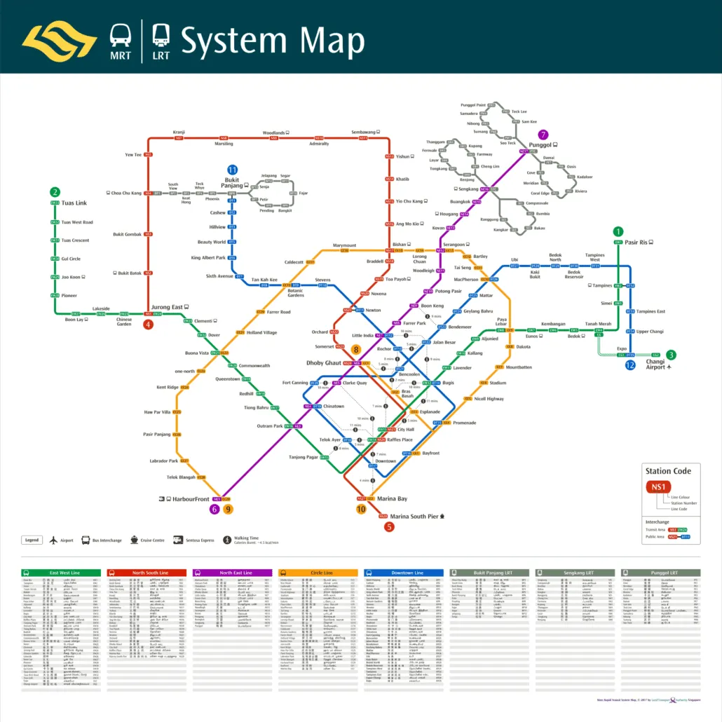
This MRT walking map is the 2017 Land Transport Authority system map with walking links added, showing the MRT and LRT network as it stood in late 2017 along with dotted lines between city centre stations that sit close enough to walk between. It records a network just after the East West Line reached Tuas Link and the Downtown Line was completed to Expo, and a few years before the Thomson-East Coast Line arrived. If you want to know when it is quicker to walk a short stretch than to change trains, this map was built for exactly that question.
What the MRT walking map shows
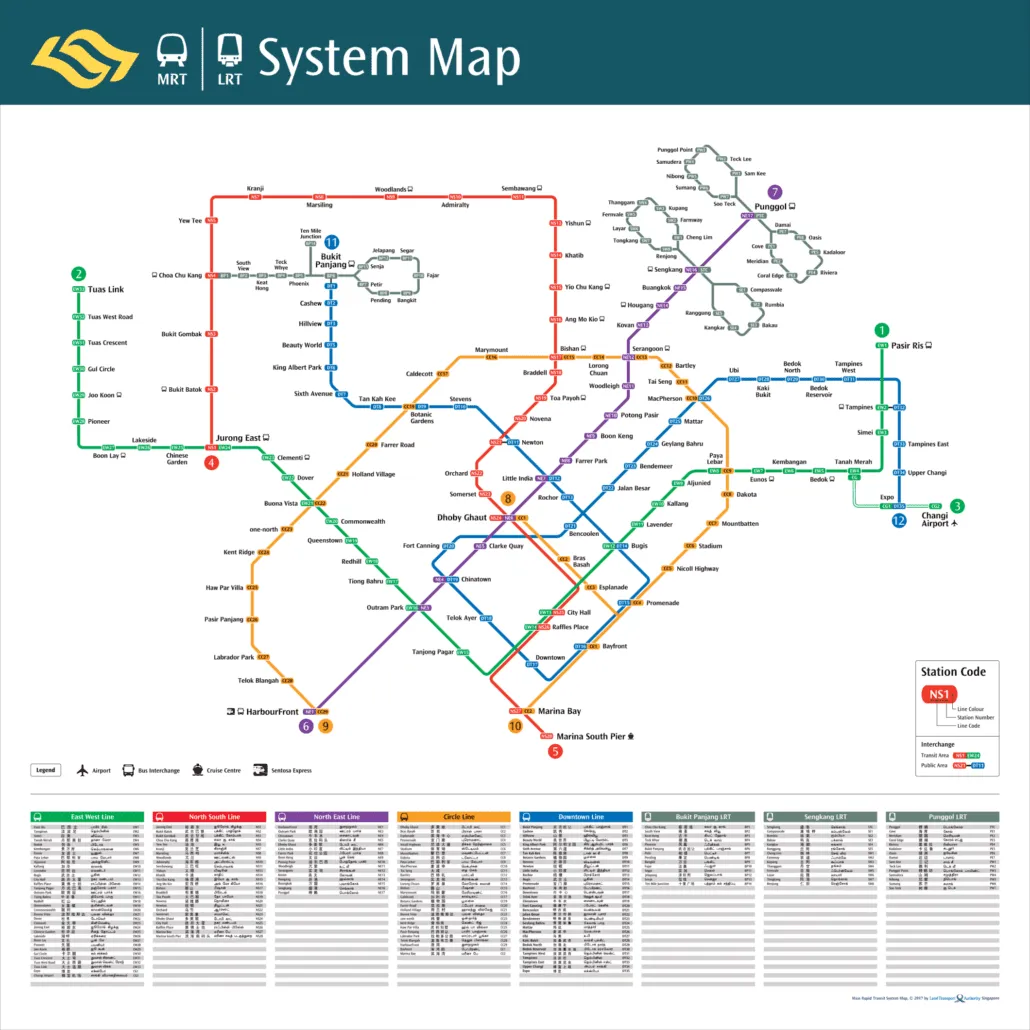
The base of the map is the standard 2017 system diagram. The North South, East West, North East, Circle and Downtown Lines are drawn in their usual colours, with the Bukit Panjang, Sengkang and Punggol LRT systems feeding into them. In the west, the East West Line runs all the way out to Tuas Link. In the east, the Downtown Line ends at Expo, where it meets the Changi Airport branch. There is no Thomson-East Coast Line anywhere on the diagram, so stations such as Woodlands North, Orchard Boulevard or Bayshore simply do not appear.
What sets this version apart is the layer of dotted links in the city centre. Each dotted line joins two stations that are near each other but not connected by a single train, and each one carries a walking time in minutes. The idea is simple. In the centre, stations on different lines are often only a short walk apart, and walking can save you a detour through an interchange or a long ride round a loop.
The legend includes an entry headed “Walking Time”. Alongside the minutes, it gives a rough guide to calories burnt, worked out at about 4.3 kcal per minute of walking. To get the figure for any link, multiply the minutes shown by 4.3. It is a light touch, but it makes the point that a walk between stations has benefits beyond the time saved.
At the bottom of the sheet is a station index listing every station name in Singapore’s four official languages: English, Chinese, Malay and Tamil. That makes the map useful for visitors and residents alike, and it is a handy reference if you want to check how a station name is written in another script.
Getting around Singapore? Find any station on the interactive MRT map, or save the PDF map to use offline.
What opened around this time
2017 was a busy year for the rail network, and the map captures it at the point where two major projects had just been finished. The key dates around it were:
- 27 December 2015: Downtown Line Stage 2 opened to passengers, a day after its official opening by Prime Minister Lee Hsien Loong.
- 18 June 2017: The Tuas West Extension of the East West Line opened, adding Gul Circle, Tuas Crescent, Tuas West Road and Tuas Link stations.
- 21 October 2017: Downtown Line Stage 3, the final stage of the line, opened to passengers. It had been officially opened the day before by Coordinating Minister for Infrastructure and Minister for Transport Khaw Boon Wan. This is the stage that took the line east to Expo.
- 2 November 2019: Canberra station opened on the North South Line, only the second infill station built on an existing line.
- 31 January 2020: The first stage of the Thomson-East Coast Line opened, the first change to the network’s line count since this map.
So the walking map belongs to a short window: after the Downtown Line was complete and before Canberra and the Thomson-East Coast Line changed the picture.
How the network has changed since
As of October 2026, the network looks noticeably different. The biggest addition is the Thomson-East Coast Line, which opened in stages from 2020 and reached Bayshore when Stage 4 opened on 23 June 2024. It now has 27 open stations, and many of them sit in the same central area covered by the walking links, so some short walks on this map now have a direct train alternative.
Other changes since 2017 include Punggol Coast on the North East Line, which opened on 10 December 2024, and Hume on the Downtown Line, which opened on 28 February 2025 as the network’s first underground infill station. Most significantly for the centre, Circle Line Stage 6 opened on 12 July 2026 with Keppel, Cantonment and Prince Edward Road, closing the Circle Line loop. On the 2017 map, the Circle Line is still a horseshoe.
| Line | Open stations (October 2026) | Ends |
|---|---|---|
| North South Line | 27 | Jurong East to Marina South Pier |
| East West Line | 33 | Pasir Ris to Tuas Link |
| East West Line (Changi Airport branch) | 2 | Expo to Changi Airport |
| North East Line | 17 | HarbourFront to Punggol Coast |
| Circle Line | 31 | Dhoby Ghaut to Prince Edward Road |
| Circle Line (Marina Bay extension) | 2 | Bayfront to Marina Bay |
| Downtown Line | 35 | Bukit Panjang to Expo |
| Thomson-East Coast Line | 27 | Woodlands North to Bayshore |
The LRT systems are also still running: the Bukit Panjang LRT with 13 stations, the Sengkang LRT with 5 on the East Loop and 8 on the West Loop, and the Punggol LRT with 7 on each loop. A handful of stations are still to come, including Marina South, Mount Pleasant, Bedok South, Sungei Bedok and Xilin. You can see how these fit into later plans on our future MRT map.
For planning a journey today, use our interactive MRT map, which reflects the current network rather than the 2017 one.
Frequently asked questions
Can I still use the 2017 MRT walking map?
The walking links between existing stations are still a reasonable guide, since the stations themselves have not moved. But the map leaves out the Thomson-East Coast Line, the closed Circle Line loop and several newer stations, so a direct train may now exist where the map suggests walking. For an up to date printable version, download our MRT map PDF.
How are the calories on the map worked out?
The legend uses a flat rate of about 4.3 kcal per minute of walking. Multiply the minutes shown on any dotted link by 4.3 for an estimate. It is a general figure, not a personal one.
Why does the Downtown Line end at Expo?
Expo is the eastern terminus of the Downtown Line. Stage 3, which took the line there, opened on 21 October 2017, so this map shows the line in its completed form. It still ends at Expo today.
How do I find the station nearest to me now?
Our nearest station finder uses the current network, including stations that opened after this map was published.
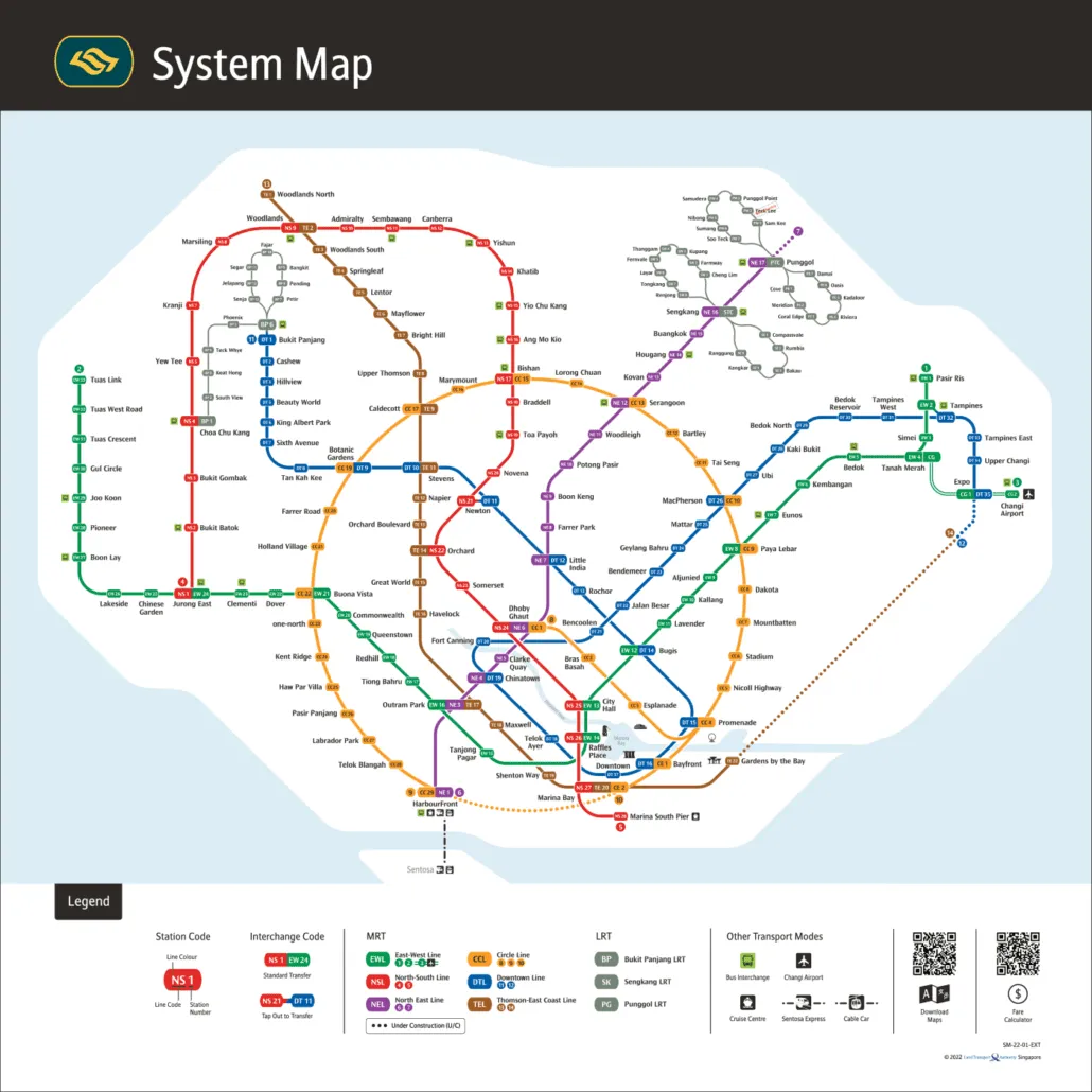
For the official version, see the LTA rail network map.