
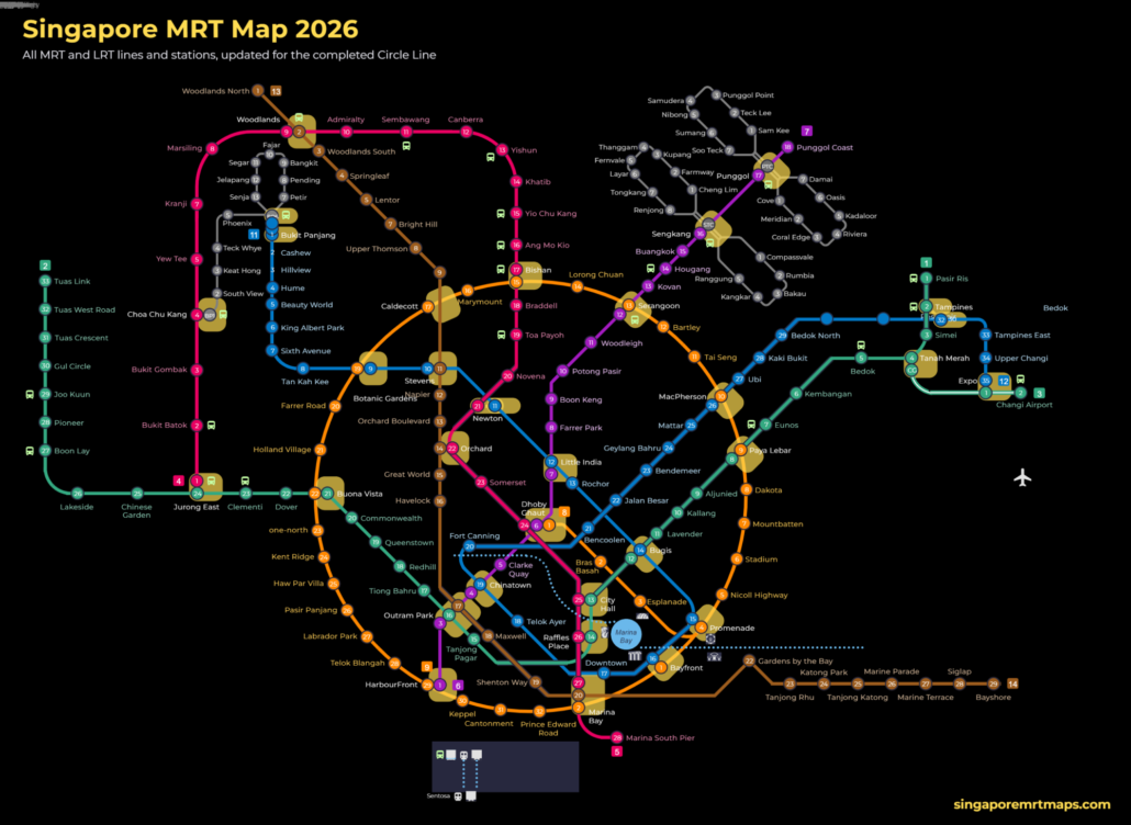
Singapore MRT line colours are the quickest way to read the map. Every line has one colour that is used on the network map, on platform signs, on the train livery and in the station code. This page lists all six MRT lines and three LRT lines by colour, with the code, number of stations, operator and the year each line opened, so you can match what you see on a sign to the right line guide.
Singapore MRT line colours: all nine lines in one table
| Colour | Line | Code | Stations open | Operator | Opened |
|---|---|---|---|---|---|
| Red | North South Line | NS | 27 | SMRT Trains | 1987 |
| Green | East West Line | EW, CG | 35 | SMRT Trains | 1987 |
| Purple | North East Line | NE | 17 | SBS Transit | 2003 |
| Yellow* | Circle Line | CC, CE | 33 | SMRT Trains | 2009 |
| Blue | Downtown Line | DT | 35 | SBS Transit | 2013 |
| Brown | Thomson-East Coast Line | TE | 27 | SMRT Trains | 2020 |
| Grey | Bukit Panjang LRT | BP | 13 | SMRT Trains | 1999 |
| Grey | Sengkang LRT | STC, SE, SW | 13 | SBS Transit | 2003 |
| Grey | Punggol LRT | PTC, PE, PW | 14 | SBS Transit | 2005 |
*Printed orange on the official map, called the yellow line by most riders. Station counts are the stations open in October 2026. The East West Line figure includes the two Changi Airport branch stations (Expo and Changi Airport). The Sengkang and Punggol LRT counts are the loop stations; the Sengkang and Punggol interchange stations are counted with the North East Line. Source: Land Transport Authority (LTA) system map and operator station lists.
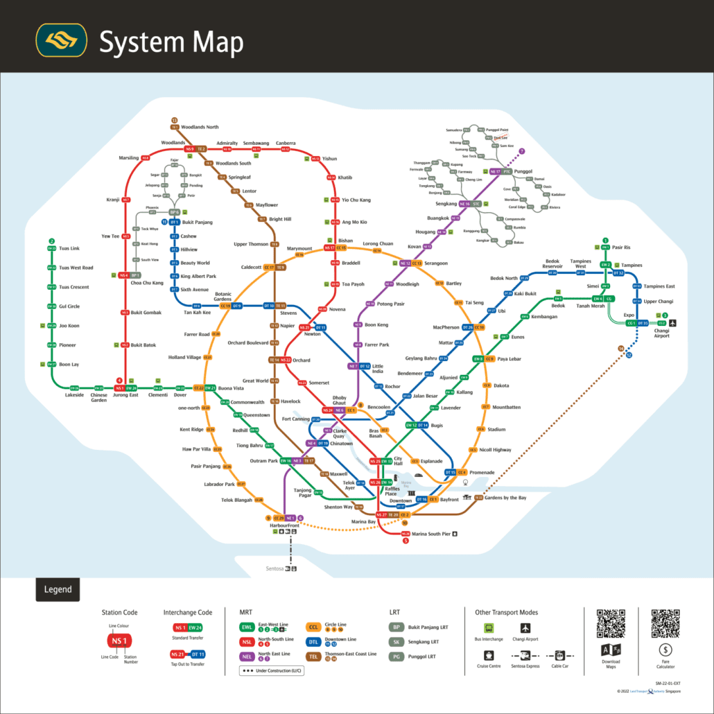
Getting around Singapore? Find any station on the interactive MRT map, or save the PDF map to use offline.
Why Singapore uses line colours
The Land Transport Authority (LTA) gives each line a colour and a two-letter code so the map works for people who do not read English. The colour appears on the line on the map, on the band above platform doors, on the coloured strip inside trains and on exit signs. The code appears in every station number, so Bugis is DT14 on the blue line and EW12 on the green line. If you remember nothing else, remember the colour and the number: a station with a bigger number is further along the line in the same direction.
Interchange stations carry two or more Singapore MRT line colours, one per line. On the map the station symbol is a white box that touches each coloured line it serves. Dhoby Ghaut, for example, touches red, purple and yellow, so you can change between the North South Line, the North East Line and the Circle Line there.
Yellow or orange: the Circle Line question
LTA prints the Circle Line in orange, but the shade on signs and trains reads as yellow to most people, so riders, taxi drivers and even some station staff call it the yellow line. Searching either word brings you to the same line. Our Circle Line guide uses both names so you can find it whichever you say. The line forms a loop around the city centre and, since the 2026 closure of the Circle Line stage 6 gap, trains run the full circle from Dhoby Ghaut through Bishan, Holland Village and HarbourFront back to Marina Bay.
Grey lines: the three LRT loops
Grey is the quietest of the Singapore MRT line colours. Bukit Panjang LRT, Sengkang LRT and Punggol LRT are all drawn in grey. They are short automated light rail loops that feed the main lines rather than trunk routes, and the grey tells you to expect small two-car trains and a change at the MRT interchange (Choa Chu Kang, Sengkang or Punggol). Fares are the same distance-based fares as the MRT, so a journey that mixes LRT and MRT is charged as one trip. See the fare table for the current bands.
Colours of the lines still being built
Two new lines appear on the future network map. The Jurong Region Line (JRL) is shown in turquoise and will serve the west, with the first stage planned for 2027. The Cross Island Line (CRL) is light green and will run across the island from Changi to Jurong, opening in stages from 2030. The Thomson-East Coast Line is already brown and will add its final stretch to Sungei Bedok, where it meets the Downtown Line, in 2026.
How to use Singapore MRT line colours when you travel
Follow the coloured band on the floor or ceiling at interchange stations: it leads to the platform for that line. On the platform, the colour of the line map above the doors confirms you are on the right side. Check the last train time before a late journey, because each colour has its own first and last train times. If you are new to the network, the MRT glossary explains the station codes and signs in more detail, and the guide to all MRT lines has one page per colour with every station listed in order.
Singapore MRT line colours: common questions
What colour is the Circle Line on the Singapore MRT map?
The Circle Line is printed in orange on the official LTA map, but most riders call it the yellow line because the shade looks yellow on station signs and on the trains. Both names mean the same line, codes CC and CE.
Which MRT line is the red line in Singapore?
The red line is the North South Line (NS). It runs from Jurong East through Woodlands, Bishan, Orchard and City Hall to Marina Bay, and it is operated by SMRT Trains.
Which MRT line is the green line?
The green line is the East West Line (EW), from Pasir Ris to Tuas Link, with the Changi Airport branch (CG) from Tanah Merah. It is the longest line on the network at 35 stations including the branch.
What is the purple line in Singapore?
The purple line is the North East Line (NE), the first fully underground driverless line, from HarbourFront to Punggol Coast. It is run by SBS Transit.
Which MRT line is blue?
The blue line is the Downtown Line (DT), 35 stations from Bukit Panjang to Expo through Newton, Bugis and Bayfront. It is run by SBS Transit.
What is the brown line on the MRT map?
The brown line is the Thomson-East Coast Line (TE). 27 stations are open from Woodlands North to Bayshore; the last stretch to Sungei Bedok is due to open in 2026.
Why are the LRT lines grey?
The three LRT lines (Bukit Panjang, Sengkang and Punggol) are all shown in grey because they are short feeder loops rather than trunk lines. The grey colour also tells you the line uses small automated light rail cars, not full MRT trains.
What colour will the Jurong Region Line and Cross Island Line be?
On LTA future network maps the Jurong Region Line (JRL) is shown in turquoise (teal) and the Cross Island Line (CRL) in light green. The JRL opens in stages from 2027 and the CRL from 2030.