
Last updated . Facts checked against LTA announcements.
Getting around a new city can feel daunting, but Singapore’s Mass Rapid Transit (MRT) makes it straightforward. The network spans the whole island and is one of the most widely used forms of public transport in Singapore, connecting residential towns, business districts and attractions alike. Once you understand the MRT map, the city opens up: from the skyscrapers of the CBD to the green spaces of the north and the beaches of the east.
The Anatomy of the Singapore MRT Map
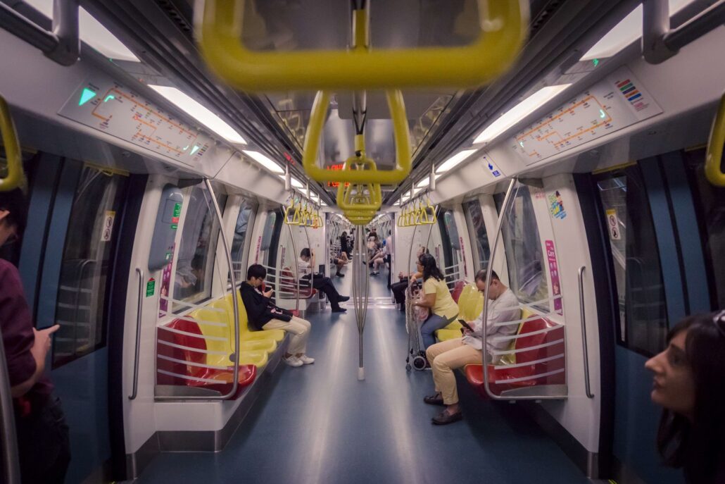
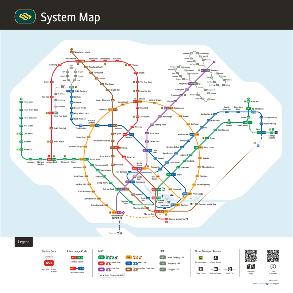
Singapore’s MRT is well regarded for its punctuality, cleanliness and coverage. The map uses colour coding to show each line and how they connect across the network.
Lines and Routes
The network is made up of six MRT lines, each with its own colour:
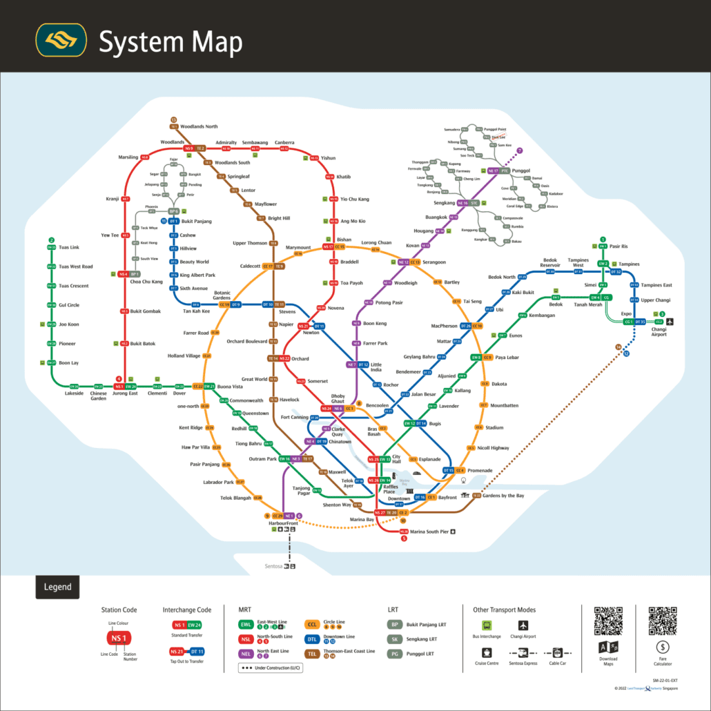
- North South Line (Red): Runs through the centre of Singapore, from Jurong East in the west to Marina South Pier in the south.
- East West Line (Green): The longest line, stretching from Pasir Ris in the east to Tuas Link in the west, with a branch to Changi Airport.
- North East Line (Purple): Runs from HarbourFront in the south to Punggol Coast in the northeast, with 17 stations in total.
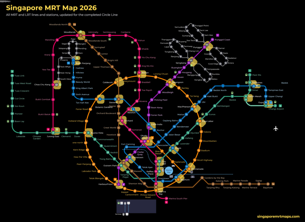
- Circle Line (Orange/Yellow): Now a full loop since Stage 6 opened on 12 July 2026, connecting stations such as Paya Lebar, Bras Basah and the new Keppel, Cantonment and Prince Edward Road stations.
- Downtown Line (Blue): Runs from Bukit Panjang in the northwest to Expo in the east, with 35 stations including the most recent addition at Hume.
- Thomson-East Coast Line (Brown): Being opened in stages, it currently serves areas from Woodlands in the north down to Bayshore in the east, with further stations due in the second half of 2026.
Three LRT (Light Rail Transit) networks, at Bukit Panjang, Sengkang and Punggol, feed into the MRT at their respective interchange stations, connecting smaller residential areas to the main rail network.
Interchange Stations
Many stations are interchanges where you can transfer between lines without tapping out and back in. City Hall and Raffles Place are key examples, both serving the North South Line and East West Line and sitting at the heart of the city centre network.
Accessibility and Convenience
Every MRT station has lifts, ramps and tactile flooring to assist passengers with mobility or visual impairments. Stations and trains are fully air-conditioned, which makes a real difference in Singapore’s heat and humidity.
Getting Around with the Map
Understanding the Map
The Singapore MRT network map uses colour-coded lines and simple symbols for stations. Interchange stations are marked differently to show where lines cross, making transfers easy to spot. You will find printed maps on platforms and inside train cabins, and digital versions are available through the TransitLink app and various online trip planners.
Ticketing Options
You can pay fares with an EZ-Link or SimplyGo card, a contactless bank card, or a mobile wallet. Cards are available at any MRT station and can be topped up when your balance runs low. If you are visiting, ask about the Singapore Tourist Pass, which offers unlimited travel for a set number of days.
Timings and Frequency
Trains run daily from around 5:30 am to midnight. During peak hours, services on busy lines run very frequently, so you rarely wait long on the platform.
Tips for a Smooth Journey
- Avoid peak hours: Travelling outside the morning and evening rush makes the journey noticeably more comfortable.
- Use mobile apps: Apps like MyTransport.SG provide real-time train arrival times and crowd information to help you plan your route.
- Follow the rules: Eating and drinking are prohibited on trains and in stations. Keeping to these rules helps maintain a clean, pleasant environment for everyone.
Discovering Singapore by MRT
The MRT puts most of Singapore’s best-known attractions within easy reach. Marina Bay Sands, Gardens by the Bay and Orchard Road are all directly served, as are cultural districts like Chinatown and Little India. Check the map, pick your line, and let the network do the work.
Conclusion
Singapore’s MRT is one of the most reliable urban rail networks in the world, and once you understand how the lines connect, getting around the city becomes straightforward. Use the MRT map to plan your route before you travel, check for any service updates on the day, and you will find that most parts of Singapore are within easy reach of a station.
For official updates on the rail network, check the Land Transport Authority (LTA) website.
Getting around Singapore? Find any station on the interactive MRT map, or save the PDF map to use offline.