
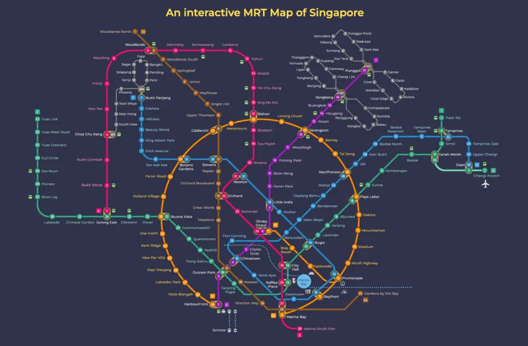
This MRT map dark mode version shows the full Singapore network on a dark background.
The Singapore MRT covers the whole island, linking neighbourhoods from Jurong in the west to Changi in the east, and Woodlands in the north to HarbourFront in the south. Whether you are heading to work, the airport, or somewhere new, every part of the city, including the Chinatown area, is within easy reach by train.
Our MRT map dark mode is a version of the Singapore rail map drawn on a dark navy background, made for reading on a phone late at night without the glare of a white page. It is an earlier edition of our own map, drawn before several openings between 2024 and 2026. That makes it comfortable on the eyes but not a complete picture of the network as it stands in October 2026. Below we set out what it shows, what it leaves out, and when to use the current map instead.
What the MRT map dark mode shows
The map reflects the network at the time it was drawn, and a few points mark its age clearly.
- Thomson-East Coast Line: drawn from Woodlands North down to Gardens by the Bay. At the time, that was as far as the line ran.
- Circle Line Stage 6: the gap between the two ends of the Circle Line is drawn as a dotted section, marked as not yet open.
- Missing stations: the map does not include Thomson-East Coast Line Stage 4 to Bayshore, Hume on the Downtown Line, or Punggol Coast on the North East Line.
Since the map was drawn, all of those gaps have been filled. The table below shows what has changed and when.
| Change | Opened | On the dark map? |
|---|---|---|
| Thomson-East Coast Line Stage 4 (Tanjong Rhu to Bayshore) | 23 June 2024 | No |
| Punggol Coast (NE18) | 10 December 2024 | No |
| Hume (DT4) | 28 February 2025 | No |
| Circle Line Stage 6 (Keppel, Cantonment, Prince Edward Road) | July 2026 | Shown dotted as not open |
The Circle Line Stage 6 opening in July 2026 closed the Circle Line loop, so the dotted section on this map is now a working part of the line. The Thomson-East Coast Line now runs for 27 open stations from Woodlands North to Bayshore, and the North East Line has 17 open stations from HarbourFront to Punggol Coast.
Getting around Singapore? Find any station on the interactive MRT map, or save the PDF map to use offline.
How to read it
Most of the map still works perfectly well for everyday trips. The trick is knowing where it has fallen behind.
- Use the station codes. Every station carries a line code such as NS, EW, NE, CC, DT or TE. On a dark background the codes are often quicker to pick out than the colours, especially when your screen brightness is turned down. Our guide to line colours explains which colour belongs to which line.
- Read the dotted Circle Line section as open. Keppel, Cantonment and Prince Edward Road are now running, and the loop is complete.
- Extend the Thomson-East Coast Line in your head. Where the map stops at Gardens by the Bay, the line now carries on from Tanjong Rhu to Bayshore.
- Remember the stations that are not drawn. Punggol Coast is now the end of the North East Line, and Hume is open on the Downtown Line as DT4.
- Do not plan around stations that are not open yet. As of October 2026, Marina South, Mount Pleasant, Bedok South, Sungei Bedok and Xilin are still not open, so check before you rely on any of them.
- Check the last train. If you are reading this map at night, the timing matters more than the colours. Our page on MRT operating hours covers first and last trains.
On a phone, pinch to zoom on interchanges rather than squinting at the whole map. The dark background makes the line colours stand out well, but the small station names in the city centre are easier to read up close.
Which map should you use?
This map is the right choice when comfort matters more than completeness. It suits late night reading in a dim room, on a dark train platform, or anywhere a bright white map feels harsh. It is also fine for familiar journeys on parts of the network that have not changed since it was drawn.
For anything else, use a current map. Here is how the options compare.
| Map | Best for |
|---|---|
| Dark mode map (this page) | Night reading and quick checks on routes that have not changed |
| Interactive MRT map | The latest network, including every station opened up to October 2026 |
| MRT map PDF | Printing, saving offline and sharing |
| Future MRT map | Lines and stations still to come |
If your journey touches Bayshore, Punggol Coast, Hume or the southern section of the Circle Line, go straight to the interactive map. The same applies if you are new to Singapore and do not yet know which parts of the network have changed. If you are not sure where to start, the nearest station finder will point you to the closest open station, and our fares and fare calculator will tell you what the trip costs.
For reference, the network today has 13 open lines and loops across MRT and LRT, from the 35 open stations on the Downtown Line to the 2 on the Changi Airport branch of the East West Line. Only the current map shows all of them as they stand.
Frequently asked questions
Is there a dark mode MRT map for Singapore?
Yes. This page shows our own dark MRT map with a navy background, designed for reading at night. It is an earlier edition, so treat it as a comfortable reading copy rather than the latest version of the network.
Is this dark MRT map up to date?
No. It was drawn before Thomson-East Coast Line Stage 4 to Bayshore (23 June 2024), Punggol Coast (10 December 2024), Hume (28 February 2025) and Circle Line Stage 6 (July 2026). For the current network, use the interactive map.
Is the Circle Line now a full loop?
Yes. Circle Line Stage 6, with Keppel, Cantonment and Prince Edward Road, opened in July 2026 and closed the loop. On this map that stretch is still drawn dotted, but trains now run through it.
Can I print the MRT map with a black background?
You can, but a dark background uses a lot of ink and the map is out of date. For a printed copy, the PDF is the better choice: it is current and much kinder to your printer.
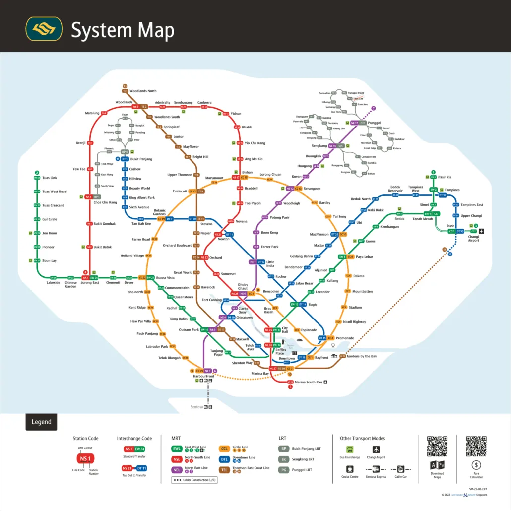
For the official version, see the LTA rail network map.